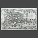
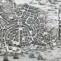
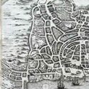
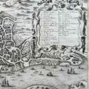

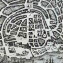
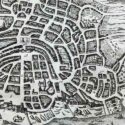
Plan de Goa
Original engraved plan by Jacques-Nicolas Bellin (1703–1772)
A detailed city map of Old Goa, situated on the banks of the Mandovi River in India. The map features a decorative cartouche, a coat of arms, and ships offshore, reflecting Goa’s historical significance as a maritime and cultural hub during the Portuguese era. Goa was seized by Afonso de Albuquerque in 1510 and became a key hub for maritime trade with Africa, the Persian Gulf, and Asia, forming part of a triangular trade network with Macau and Nagasaki. It also served as the Jesuit Order’s eastern headquarters under St. Francis Xavier. Renowned for its architecture, including the Viceroy’s Palace and Se Cathedral, Goa flourished as a commercial and religious center. Despite challenges from rising Dutch power, Goa remained the “Golden City” of Portuguese controlled Asia.
Jacques-Nicolas Bellin was a pivotal figure in 18th-century cartography, serving as Hydrographer to the French Navy and the first Ingénieur Hydrographe at the French Dépôt des cartes et plans de la Marine. Over a 50-year career, Bellin produced hundreds of maps and charts celebrated for their accuracy and functionality, setting a high standard in European cartography. His works included major sea atlases such as Neptune François (1753), Hydrographie Française (1756), and the comprehensive Petit Atlas Maritime (1764), featuring 580–581 finely detailed charts. Bellin also contributed extensively to Diderot’s Encyclopédie and Abbé Prévost’s Histoire Générale des Voyages. A child of the Enlightenment, Bellin prioritized scholarly precision and cited his sources diligently, distinguishing his work from the more decorative styles of earlier mapmakers. His contributions cemented France’s dominance in cartography and influenced his student, Rigobert Bonne, who succeeded him at the Dépôt.