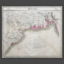
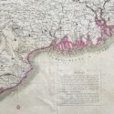
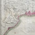
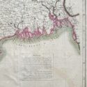
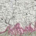
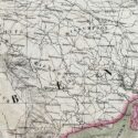
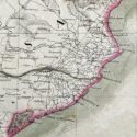
Bengale
Original lithographed map by Philippe Vandermaelen (1795-1869)
Image Size (cms): 49.5(H) x 57(W)
Image Size (inches): 19.5(H) x 22.5(W)

Original lithographed map by Philippe Vandermaelen (1795-1869)
An attractive map from Atlas Universel de Geographie depicts parts of present-day Bangladesh, Bihar, Orissa, West Bengal, and Tripura. This atlas was groundbreaking as the first to present all maps on a uniform scale of 1:1,641,836, with each map covering approximately 20 degrees of longitude (from Paris) and 6 degrees of latitude. Published between 1825 and 1827 in a single edition with 810 copies sold, it offered unprecedented detail for many regions, particularly the American West. The maps were hand-painted in outline colour, showcasing remarkable craftsmanship.
Philippe Marie Guillaume Vandermaelen (1795–1869), the Flemish cartographer behind this monumental work, was a native of Brussels and initially trained as a globe maker. His innovative vision of mapping on a universal scale was likely influenced by this early training. Beyond the Atlas Universel, Vandermaelen created globes, regional maps, a 250-sheet map of Belgium, and other significant works, establishing himself as a key figure in 19th-century cartography.
Image Size (cms): 49.5(H) x 57(W)
Image Size (inches): 19.5(H) x 22.5(W)