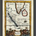
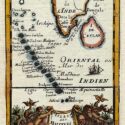
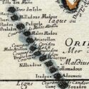
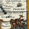
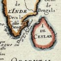
Isles ded Maldives
Original engraved map by A.M. Mallet (1630-1706)
Size (cms): 17.5(H) x 13.5(W)
Size (inches): 7(H) x 5.5(W)

Original engraved map by A.M. Mallet (1630-1706)
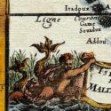
This detailed map of the Maldives, southwest of the southern tip of India, showcases excellent detail and features a decorative title cartouche and vignette at the bottom. It originates from Mallet’s monumental Description de L’Univers, first published in Paris in 1683, regarded as one of the greatest works of its kind in the 17th century.
Alain Manesson Mallet (1630–1706), a French cartographer and engineer, began his career as a soldier in the army of Louis XIV, later becoming a Sergeant-Major in the artillery and an Inspector of Fortifications. He also served under the King of Portugal before returning to France, where he was appointed to the court of Louis XIV and taught mathematics. Mallet’s major publications include Description de L’Univers (1683) in five volumes, from which this map originates, and Les Travaux de Mars ou l’Art de la Guerre (1684) in three volumes.
Description de L’Univers encompasses a wide range of information, including star maps, maps of both the ancient and modern worlds, and a summary of the customs, religions, and governments of various nations. It is suggested that Mallet’s teaching background influenced his focus on entertaining readers, as reflected in the charming harbour scenes and rural landscapes he included beneath his descriptions of astronomical concepts and diagrams. Most of the figures engraved for this work were drawn by Mallet himself.
Size (cms): 17.5(H) x 13.5(W)
Size (inches): 7(H) x 5.5(W)