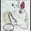
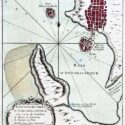

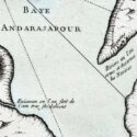
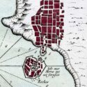

Plan de Andarajapour
Original engraved plan by Jacques-Nicolas Bellin (1703–1772)
This finely engraved map depicts Andarajapour (also known as Rajapur), taken from Jacques-Nicolas Bellin’s Le Petit Atlas Maritime, first published in Paris in 1764. Rajapur, a small yet historically significant port on Maharashtra’s Konkan coast, was a vital maritime center during the Bijapur Sultanate, benefiting from a navigable creek that connected it to the Arabian Sea. In 1668, under Shivaji’s reign, the French East India Company was granted permission to establish a factory in Rajapur, aiming to capitalize on the export of spices and textiles.
Jacques-Nicolas Bellin was a pivotal figure in 18th-century cartography, serving as Hydrographer to the French Navy and the first Ingénieur Hydrographe at the French Dépôt des cartes et plans de la Marine. Over a 50-year career, Bellin produced hundreds of maps and charts celebrated for their accuracy and functionality, setting a high standard in European cartography. His works included major sea atlases such as Neptune François (1753), Hydrographie Française (1756), and the comprehensive Petit Atlas Maritime (1764), featuring 580–581 finely detailed charts. Bellin also contributed extensively to Diderot’s Encyclopédie and Abbé Prévost’s Histoire Générale des Voyages. A child of the Enlightenment, Bellin prioritized scholarly precision and cited his sources diligently, distinguishing his work from the more decorative styles of earlier mapmakers. His contributions cemented France’s dominance in cartography and influenced his student, Rigobert Bonne, who succeeded him at the Dépôt.