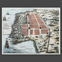
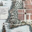
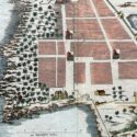
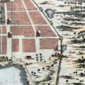
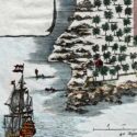
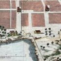
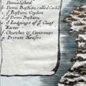

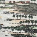
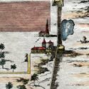
Plan of Cowlang
Original engraved plan by Philippus Baldaeus (1632-1672)
This original engraved plan by Philippus Baldaeus (1632–1672) appears in Naauwkeurige Beschryvinge van Malabar en Choromandel (1672) and was re-issued in A Collection of Voyages & Travels (1704–52). Baldaeus, a Dutch Reformed Church minister, served in the Dutch East Indies and documented South India and Ceylon’s culture, history, and religion. Fluent in Tamil, Portuguese, and Sanskrit, he was among the first Europeans to extensively write about Hinduism, introducing Indian mythology, the Ramayana, and the Mahabharata to European audiences.
Dutch India (1605–1825) comprised regions like Dutch Ceylon, Coromandel, Malabar, Bengal, and Suratte. The Dutch East India Company traded textiles, spices, precious stones, indigo, silk, and pepper, with notable mints in Cochin, Negapatam, and Pulicat. However, the Dutch influence waned after the 1741 Battle of Colachel, and their remaining territories were ceded to the British under the Anglo-Dutch Treaty of 1824, marking the end of their presence in India.