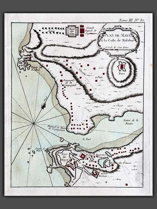
Filter products Showing 273 - 288 of 369 results
Sort By
Show Per Page
Filter products Showing 273 - 288 of 369 results
Sort By
Show Per Page
  • plan de mayeplan de maye

    Plan de Maye

    Original engraved plan by Jacques-Nicolas Bellin (1703–1772)

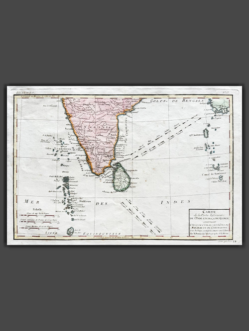
    This finely engraved plan depicts Mayyazhi (also known as Mahé), taken from Jacques Nicolas Bellin’s Le Petit Atlas Maritime, first published in Paris in 1764. Situated at the mouth of the Mayyazhi River in southern coastal India, Mahé retains a significant French colonial heritage, visible even today. The colonial legacy is evident in this map, with several landmarks identified as belonging to the French East India Company, alongside notable structures such as a French church.

    Jacques-Nicolas Bellin was a pivotal figure in 18th-century cartography, serving as Hydrographer to the French Navy and the first Ingénieur Hydrographe at the French Dépôt des cartes et plans de la Marine. Over a 50-year career, Bellin produced hundreds of maps and charts celebrated for their accuracy and functionality, setting a high standard in European cartography. His works included major sea atlases such as Neptune François (1753), Hydrographie Française (1756), and the comprehensive Petit Atlas Maritime (1764), featuring 580–581 finely detailed charts. Bellin also contributed extensively to Diderot’s Encyclopédie and Abbé Prévost’s Histoire Générale des Voyages. A child of the Enlightenment, Bellin prioritized scholarly precision and cited his sources diligently, distinguishing his work from the more decorative styles of earlier mapmakers. His contributions cemented France’s dominance in cartography and influenced his student, Rigobert Bonne, who succeeded him at the Dépôt.

    Image Size (cms): 24(H) x 19(W)
    Image Size (inches): 9.5(H) x 7.5(W)
  • plan of cowlangplan of cowlang

    Plan of Cowlang

    Original engraved plan by Philippus Baldaeus (1632-1672)

    This original engraved plan by Philippus Baldaeus (1632–1672) appears in Naauwkeurige Beschryvinge van Malabar en Choromandel (1672) and was re-issued in A Collection of Voyages & Travels (1704–52). Baldaeus, a Dutch Reformed Church minister, served in the Dutch East Indies and documented South India and Ceylon’s culture, history, and religion. Fluent in Tamil, Portuguese, and Sanskrit, he was among the first Europeans to extensively write about Hinduism, introducing Indian mythology, the Ramayana, and the Mahabharata to European audiences.

    Quilon (Cowlang or Kollam), one of the oldest ports on Kerala’s Malabar Coast, has a rich history of maritime trade dating back to the Phoenicians, Romans, and Chinese. By the 9th century, it became a major trade hub, exporting spices, pearls, sapphires, and silk. The Portuguese fortified it in the 16th century, but by 1661, the Dutch took control, restructuring trade networks and exporting pepper and coir. The Dutch fort played a key role until the British took over in the late 18th century.

    Dutch India (1605–1825) comprised regions like Dutch Ceylon, Coromandel, Malabar, Bengal, and Suratte. The Dutch East India Company traded textiles, spices, precious stones, indigo, silk, and pepper, with notable mints in Cochin, Negapatam, and Pulicat. However, the Dutch influence waned after the 1741 Battle of Colachel, and their remaining territories were ceded to the British under the Anglo-Dutch Treaty of 1824, marking the end of their presence in India.

    Image Size (cms): 30(H) x 37(W)
    Image Size (inches): 12(H) x 14.5(W)
  • plan of cranganoreplan of cranganore

    Plan of Cranganore

    Original engraved plan by Philippus Baldaeus (1632-1672)

    This original engraved plan by Philippus Baldaeus (1632-1672) appears in Naauwkeurige Beschryvinge van Malabar en Choromandel (1672) and was re-issued in A Collection of Voyages & Travels (1704–52). Baldaeus, a Dutch Reformed Church minister, served in the Dutch East Indies and documented South India and Ceylon’s culture, history, and religion. Fluent in Tamil, Portuguese, and Sanskrit, he was among the first Europeans to extensively write about Hinduism, introducing Indian mythology, the Ramayana, and the Mahabharata to European audiences.

    Cranganore, once part of the Later Chera dynasty’s capital Mahodayapuram, was a key trade hub connected to the Roman Empire through the nearby port of Muziris, exporting goods like pepper, pearls, and ivory. It later became a tributary state under the Zamorin of Calicut and faced conflicts with the Kingdom of Cochin. The Portuguese destroyed it in 1504, the Dutch captured it in 1663, and in 1789, they sold it to the Kingdom of Travancore, ending their influence in the region.

    Dutch India (1605–1825) comprised regions like Dutch Ceylon, Coromandel, Malabar, Bengal, and Suratte. The Dutch East India Company traded textiles, spices, precious stones, indigo, silk, and pepper, with notable mints in Cochin, Negapatam, and Pulicat. However, the Dutch influence waned after the 1741 Battle of Colachel, and their remaining territories were ceded to the British under the Anglo-Dutch Treaty of 1824, marking the end of their presence in India.

    Image Size (cms): 29(H) x 37(W)
    Image Size (inches): 11.5(H) x 14.5(W)
  • plan of fort geldria in pellacataplan of fort geldria in pellacata

    Plan of Fort Geldria in Pellacata

    Original engraved plan by Phillipus Baldaeus (1632-1672)

    This original engraved plan by Phillipus Baldaeus (1632–1672) appears in Naauwkeurige Beschryvinge van Malabar en Choromandel (1672) and was re-issued in A Collection of Voyages & Travels (1704–52). Baldaeus, a Dutch Reformed Church minister, served in the Dutch East Indies and documented South India and Ceylon’s culture, history, and religion. Fluent in Tamil, Portuguese, and Sanskrit, he was among the first Europeans to extensively write about Hinduism, introducing Indian mythology, the Ramayana, and the Mahabharata to European audiences.

    Pulicat (Pellacata), located at the mouth of Pulicat Lake in Tamil Nadu, was a prominent seaport with a history dating back to 300 BCE. Controlled by various rulers, including Arabs, Portuguese, Dutch, and British, it became a multicultural hub with over 50,000 people in the 16th century. The Dutch established Fort Geldria in 1613, making it their stronghold until 1690. Pulicat later regained importance after 1781 and became a major center for cotton trade and the Dutch slave trade, with over 38,000 slaves shipped from its ports between 1621 and 1665.

    Dutch India (1605–1825) comprised regions like Dutch Ceylon, Coromandel, Malabar, Bengal, and Suratte. The Dutch East India Company traded textiles, spices, precious stones, indigo, silk, and pepper, with notable mints in Cochin, Negapatam, and Pulicat. However, the Dutch influence waned after the 1741 Battle of Colachel, and their remaining territories were ceded to the British under the Anglo-Dutch Treaty of 1824, marking the end of their presence in India.

    Image Size (cms): 30(H) x 38(W)
    Image Size (inches): 12(H) x 15(W)
  • plan of negapatamplan of negapatam

    Plan of Negapatam

    Original engraved plan by Philippus Baldaeus (1632-1672)

    This original engraved plan by Philippus Baldaeus (1632–1672) appears in Naauwkeurige Beschryvinge van Malabar en Choromandel (1672) and was re-issued in A Collection of Voyages & Travels (1704–52). Baldaeus, a Dutch Reformed Church minister, served in the Dutch East Indies and documented South India and Ceylon’s culture, history, and religion. Fluent in Tamil, Portuguese, and Sanskrit, he was among the first Europeans to extensively write about Hinduism, introducing Indian mythology, the Ramayana, and the Mahabharata to European audiences.

    Negapatam, a prominent Chola port from the 9th–12th century, housed the Chudamani Vihara, a significant Buddhist structure built by the Sri Lankan king with Chola support. The Portuguese later settled here, followed by the Dutch, who made it the capital of Dutch Coromandel (1660–1781). It came under British control in 1781 and served as Tanjore district’s capital under the Madras Presidency (1799–1845).

    Dutch India (1605–1825) comprised regions like Dutch Ceylon, Coromandel, Malabar, Bengal, and Suratte. The Dutch East India Company traded textiles, spices, precious stones, indigo, silk, and pepper, with notable mints in Cochin, Negapatam, and Pulicat. However, the Dutch influence waned after the 1741 Battle of Colachel, and their remaining territories were ceded to the British under the Anglo-Dutch Treaty of 1824, marking the end of their presence in India.

    Image Size (cms): 38(H) x 31(W)
    Image Size (inches): 15(H) x 12(W)
  • plan of pellacataplan of pellacata

    Plan of Pellacata

    Original engraved plan by Philippus Baldaeus (1632-1672)

    This original engraved plan by Philippus Baldaeus (1632–1672) appears in Naauwkeurige Beschryvinge van Malabar en Choromandel (1672) and was re-issued in A Collection of Voyages & Travels (1704–52). Baldaeus, a Dutch Reformed Church minister, served in the Dutch East Indies and documented South India and Ceylon’s culture, history, and religion. Fluent in Tamil, Portuguese, and Sanskrit, he was among the first Europeans to extensively write about Hinduism, introducing Indian mythology, the Ramayana, and the Mahabharata to European audiences.

    Pulicat (Pellacata), located at the mouth of Pulicat Lake in Tamil Nadu, was a prominent seaport with a history dating back to 300 BCE. Controlled by various rulers, including Arabs, Portuguese, Dutch, and British, it became a multicultural hub with over 50,000 people in the 16th century. The Dutch established Fort Geldria in 1613, making it their stronghold until 1690. Pulicat later regained importance after 1781 and became a major center for cotton trade and the Dutch slave trade, with over 38,000 slaves shipped from its ports between 1621 and 1665.

    Dutch India (1605–1825) comprised regions like Dutch Ceylon, Coromandel, Malabar, Bengal, and Suratte. The Dutch East India Company traded textiles, spices, precious stones, indigo, silk, and pepper, with notable mints in Cochin, Negapatam, and Pulicat. However, the Dutch influence waned after the 1741 Battle of Colachel, and their remaining territories were ceded to the British under the Anglo-Dutch Treaty of 1824, marking the end of their presence in India.

    Image Size (cms): 29.5(H) x 37.5(W)
    Image Size (inches): 11.5(H) x 15(W)
  • plan of tutecorynplan of tutecoryn

    Plan of Tutecoryn

    Original engraved plan by Philippus Baldaeus (1632-1672)

    This original engraved plan by Philippus Baldaeus (1632-1672) appears in Naauwkeurige Beschryvinge van Malabar en Choromandel (1672) and was re-issued in A Collection of Voyages & Travels (1704–52). Baldaeus, a Dutch Reformed Church minister, served in the Dutch East Indies and documented South India and Ceylon’s culture, history, and religion. Fluent in Tamil, Portuguese, and Sanskrit, he was among the first Europeans to extensively write about Hinduism, introducing Indian mythology, the Ramayana, and the Mahabharata to European audiences.

    Tutecoryn, known as the “Pearl City,” has been a major seaport since the 6th century, serving as a gateway to Tamil Nadu and Southern India. The town’s rulers over centuries included the Pandyas, Cholas, Ma’bar Sultanate, Vijayanagar Empire, Nayaks, and various colonial powers such as the Portuguese, Dutch, and British East India Company. The town’s pearl fishing and maritime trade brought it global recognition, making it an essential node for commerce and culture.

    Dutch India (1605–1825) comprised regions like Dutch Ceylon, Coromandel, Malabar, Bengal, and Suratte. The Dutch East India Company traded textiles, spices, precious stones, indigo, silk, and pepper, with notable mints in Cochin, Negapatam, and Pulicat. However, the Dutch influence waned after the 1741 Battle of Colachel, and their remaining territories were ceded to the British under the Anglo-Dutch Treaty of 1824, marking the end of their presence in India.

    Image Size (cms): 30.5(H) x 37.5(W)
    Image Size (inches): 12(H) x 15(W)
  • l'inde de ca le gange (copy)l'inde de ca le gange (copy)

    South India

    Original engraved map by Pieter van den aa (1659-1733)

    This map, created by Rigobert Bonne and G. Raynal in 1784, depicts Southern India, Sri Lanka, the Maldives, and the Andaman and Nicobar Islands. It includes arrows indicating the direction of trade winds across the Indian Ocean, showing seasonal patterns. The map is highly detailed, displaying towns, rivers, topographical features, ports, and political boundaries. It was part of G. Raynal’s Atlas de Toutes les Parties Connues du Globe Terrestre, published alongside L’Histoire Philosophique et Politique des Établissemens et du Commerce des Européens dans les Deux Indes.

    Bonne (1727–1794) was a notable French cartographer, mathematician, and engineer, renowned for his accurate and detailed maps. Succeeding Jacques-Nicolas Bellin as Royal Cartographer to France in 1773, he was a key figure in the shift from decorative cartography to a more scientific approach. His work, especially focusing on coastal regions, is admired for both its precision and aesthetic quality.

    Image Size (cms): 23.5(H) x 34(W)
    Image Size (inches): 9.5(H) x 13.5(W)

  • view of ahmedabadview of ahmedabad

    View of Ahmedabad

    Original engraved plan by Phillipus Baldaeus (1632-1672)

    This original engraved plan by Phillipus Baldaeus (1632–1672) appears in Naauwkeurige Beschryvinge van Malabar en Choromandel (1672) and was re-issued in A Collection of Voyages & Travels (1704–52). Baldaeus, a Dutch Reformed Church minister, served in the Dutch East Indies and documented South India and Ceylon’s culture, history, and religion. Fluent in Tamil, Portuguese, and Sanskrit, he was among the first Europeans to extensively write about Hinduism, introducing Indian mythology, the Ramayana, and the Mahabharata to European audiences.

    Ahmedabad, Gujarat’s largest city, is located along the Sabarmati River in western India. Established in 1411, by Ahmed Shah I of the Gujarat Sultanate, it became a political and economic center. While its origins trace back to the 12th century under the Solanki dynasty, the city thrived during the Sultanate (1411–1511) and experienced renewed prosperity under Mughal rule (1572–1707). Once hailed as ‘the greatest city in India,’ Ahmedabad was renowned for its rich silks and gold-embroidered textiles, attracting traders like the Dutch and English.

    The Dutch East India Company (VOC) played a significant role in Ahmedabad’s history from 1615 to 1744. They established the Dutch Factory, or ‘Dutch Haveli,’ in 1617, a complex inspired by Indo-Islamic and Mughal architecture with elegant arches and asymmetrical wings. The factory was a hub for trading cotton, indigo, and silk yarn. Additionally, the Dutch cemetery in Ahmedabad remains a historical marker of their influence and the lives of those who settled in the city.

    Image Size (cms): 30(H) x 37(W)
    Image Size (inches): 12(H) x 14.5(W)
  • Agricultural Seeder

    Agricultural Seeder

    Central India

    Wood

    A lovely wooden seeder that is ornately carved and decorated. Displays wear consistent with age and use. It would have once been used by farmers as a sowing tool for sunflower, jowar (sorghum) and groundnuts. The seeders would be connected with pipes to sow seeds in simultaneous rows and would be used along with a plough pulled by a bull. On one side, a couple is depicted using a seeder while on the other, a pair of peacocks are intertwined. On either side of the seeder, parrots are carved in high relief.

    Size(cms): 21 (H) x 22.5 (W) x 12.5 (D)
    Size(inches): 8.3 (H) x 8.9 (W) x 4.9 (D)

  • buddhabuddha

    Buddha

    Burma (Myanmar)

    Bronze

    This charming figure of Buddha depicts him seated in bhumispara mudra (‘calling the earth to witness’). The image wears a sanghati with a long sash that reaches to the waist. The cranial protuberance or usnisha is surrounded by a crown on top of his head.

    The posture in which the monks are seated is usually known as the ‘earth-witness’ attitude. This represents the moment when Buddha was seated in meditation under the Bodhi tree during the night before he achieved enlightenment. When he was asked by Mara to name anyone who would give evidence that he had given alms, the Buddha moved his right hand and touched the earth and said that the earth would bear witness that, in a previous existence in the form of Vessantara, he had given alms to such an extent as to cause the earth to quake. Immediately before this incident his right hand was folded in his lap in precisely the same way as his left; here he has moved it in order to touch the earth in front of him in the gesture of calling the earth to witness (bhumisparsha mudra). This is one of the three most popular ways of showing the Buddha in Burmese art; the other two represent him standing and at the moment of his Mahaparinibbana.

    Size (cms): 12(H) x 6(W) x 4(D)
    Size (inches): 4.5(H) x 2.5(W) x 1.5(D)

  • Devi (Goddess) Hand

    Devi (Goddess) Hand

    Karnataka

    Wood, polychromed

    A finely carved wooden hand, with original polychroming wearing bangles. She holds a blood bowl within her clenched fist and a diminutive lingam marks her forearm. Originally from an articulated multi-armed processional figure of a Devi. During festive occasions, the utsavar (portable figures of deities) are placed on chariots or pedestals in the mandapam (audience hall of a temple) or on their respective vahana (vehicle) and taken out for public viewing or darshanaDarshana refers to the occasion where the devotee is not only able to see the image of the deity but also to sense its omnipresence. To enhance the visibility of the utsavar, they are elaborately dressed in dhoti or sari, garlanded with flowers and decked with the most exquisite jewellery, made of gold and semi-precious stones before being brought out in procession. Sometimes additional hands or legs are added to increase the physical presence of the image. These features may allow the deity to stand, sit or clasp multiple weapons.

    Size with the Stand (cms):29(H) x 13(W) x 7.5(D)
    Size with the Stand (inches): 11.5(H) x 5(W) x 3(D)

  • Devi (Goddess) Hand

    Devi (Goddess) Hand

    Karnataka

    Wood, polychromed

    A finely carved wooden hand, with original polychroming wearing bangles and rings. Originally from an articulated multi-armed processional figure of a Devi. During festive occasions, the utsavar (portable figures of deities) are placed on chariots or pedestals in the mandapam (audience hall of a temple) or on their respective vahana (vehicle) and taken out for public viewing or darshana. Darshana refers to the occasion where the devotee is not only able to see the image of the deity but also to sense its omnipresence. To enhance the visibility of the utsavar, they are elaborately dressed in dhoti or sari, garlanded with flowers and decked with the most exquisite jewellery, made of gold and semi-precious stones before being brought out in procession. Sometimes additional hands or legs are added to increase the physical presence of the image. These features may allow the deity to stand, sit or clasp multiple weapons.

    Size with the Stand (cms): 34(H) x 13(W) x 7.5(D)
    Size with the Stand (inches): 13.5(H) x 5(W) x 3(D)

  • devi (goddess) hand (copy)devi (goddess) hand (copy)

    Devi (Goddess) Hand

    Karnataka

    Wood, polychromed

    A finely carved wooden hand, with original polychroming wearing bangles. Her hand is held in a clenched fist. Originally from an articulated multi-armed processional figure of a Devi. During festive occasions, the utsavar (portable figures of deities) are placed on chariots or pedestals in the mandapam (audience hall of a temple) or on their respective vahana (vehicle) and taken out for public viewing or darshana. Darshana refers to the occasion where the devotee is not only able to see the image of the deity but also to sense its omnipresence. To enhance the visibility of the utsavar, they are elaborately dressed in dhoti or sari, garlanded with flowers and decked with the most exquisite jewellery, made of gold and semi-precious stones before being brought out in procession. Sometimes additional hands or legs are added to increase the physical presence of the image. These features may allow the deity to stand, sit or clasp multiple weapons.

    Size with the Stand (cms): 36.5(H) x 13(W) x 7.5(D)
    Size with the Stand (inches):14.5(H) x 5(W) x 3(D)

  • Male Morung Figure

    Male Morung Figure

    Nagaland (North-East India)

    Wood

    Male standing figure adorned with red and white glass bead necklaces. Carved from solid trunks of trees, the solemn expressions of these wood sculptures sometimes heightened by cowrie shells, bead necklaces or human and animal hair, combined with the blunt tubular carving on dark wood give these Naga figures a silent though persuasive identity.

    A key fixture in nearly all Naga settlements was the Morung, or Men’s House, which served as something of a community center. It was usually the biggest and most beautifully furnished building in a village, spacious and decorated with ornate carvings. Numerous wooden sculptures decorated the walls and posts of the farthest end of the innermost space of the Morung. They expressed the narrative traditions of the Naga. Wooden sculpture such as this, depicting would be posted near the walls of the Morung, were not uncommon and thought to relate to fertility.

    The Naga are a group of culturally and linguistically linked tribes who live in the mountainous regions of northeastern India and northwestern Burma (Myanmar). As headhunters, they were feared and avoided by their neighbours, allowing them to develop a distinctive material culture—in which objects they created are of impressive aesthetic value and possess great symbolic importance to the community—and a complex system of norms and taboos.

    Size (cms): 46(H) x 9(W) x 7(D)
    Size (inches): 18(H) x 3.5(W) x 3(D)

  • Morung Figure

    Morung Figure

    Nagaland (North-East India)

    Wood and glass

    A key fixture in nearly all Naga settlements was the Morung, or Men’s House, which served as something of a community center. It was usually the biggest and most beautifully furnished building in a village, spacious and decorated with ornate carvings. Numerous wooden sculptures decorated the walls and posts of the farthest end of the innermost space of the Morung. They expressed the narrative traditions of the Naga. Wooden sculpture such as this, depicting would be posted near the walls of the Morung, were not uncommon and thought to relate to fertility.

    The Naga are a group of culturally and linguistically linked tribes who live in the mountainous regions of northeastern India and northwestern Burma (Myanmar). As headhunters, they were feared and avoided by their neighbours, allowing them to develop a distinctive material culture—in which objects they created are of impressive aesthetic value and possess great symbolic importance to the community—and a complex system of norms and taboos. The main tribal groups of the Naga include the Angami, Sema, Ao, Kalyo- Kengyu, Konyak, Lhota, Rengma, Tangkhul, Chang, Sangtam and Sema.

    Size(cms): 53 (H) x 13 (W) x 8 (D)
    Size(inches): 20.9 (H) x 5.1 (W) x 3.1 (D)

Phillips Antiques

PHILLIPS

Subscribe to our Newsletter to stay updated with newest arrivals.
SUBSCRIBE NOW
close-link