“Map of Madras” has been added to your cart.
View cart
-
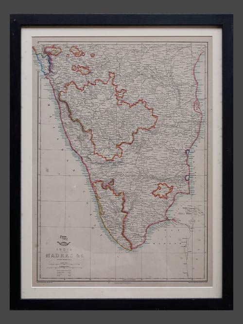

by Edward Weller
from Weekly Dispatch Atlas
original engraved map
Edward Weller was a cartographer and engraver based in London. His best known work appears in Cassell’s Weekly Dispatch Atlas, published in monthly segments for subscribers of the “Weekly Dispatch” newspaper. The maps are characterised by their detail and attractive outline colour and up to date information. The majority have an emblematical design of the upper half of a globe with a scroll “the Dispatch atlas” wrapped round it and above is the flying figure of Mercury (messenger of the Gods) .
Size of print (cms): 45 (H) x 32 (L)
Size of print (inches): 17.7 (H) x 12.6 (L)
Size framed (cms): 53 (H) x 40 (L)
Size framed (inches): 20.8 (H) x 15.7 (L)
-
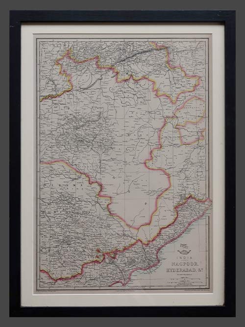

by Edward Weller
from Weekly Dispatch Atlas
original engraved map
Edward Weller was a cartographer and engraver based in London. His best known work appears in Cassell’s Weekly Dispatch Atlas, published in monthly segments for subscribers of the “Weekly Dispatch” newspaper. The maps are characterised by their detail and attractive outline colour and up to date information. The majority have an emblematical design of the upper half of a globe with a scroll “the Dispatch atlas” wrapped round it and above is the flying figure of Mercury (messenger of the Gods) .
Size of print (cms): 45 (H) x 32 (L)
Size of print (inches): 17.7 (H) x 12.6 (L)
Size framed (cms): 53 (H) x 40 (L)
Size framed (inches): 20.8 (H) x 15.7 (L)
-
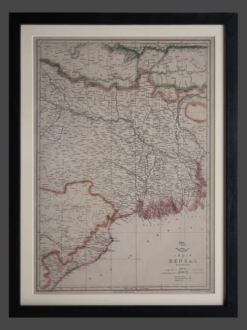

by Edward Weller from Weekly Dispatch Atlas
original engraved map
Edward Weller was a cartographer and engraver based in London. His best known work appears in Cassell’s Weekly Dispatch Atlas, published in monthly segments for subscribers of the “Weekly Dispatch” newspaper. The maps are characterised by their detail and attractive outline colour and up to date information. The majority have an emblematical design of the upper half of a globe with a scroll “the Dispatch atlas” wrapped round it and above is the flying figure of Mercury (messenger of the Gods) .
Size of print (cms): 45 (H) x 32 (L)
Size of print (inches): 17.7 (H) x 12.6 (L)
Size framed (cms): 53 (H) x 40 (L)
Size framed (inches): 20.8 (H) x 15.7 (L)
-
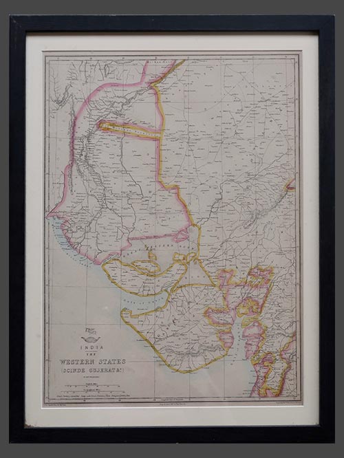

by Edward Weller
from Weekly Dispatch Atlas
original engraved map
Edward Weller was a cartographer and engraver based in London. His best known work appears in Cassell’s Weekly Dispatch Atlas, published in monthly segments for subscribers of the “Weekly Dispatch” newspaper. The maps are characterised by their detail and attractive outline colour and up to date information. The majority have an emblematical design of the upper half of a globe with a scroll “the Dispatch atlas” wrapped round it and above is the flying figure of Mercury (messenger of the Gods) .
Size of print (cms): 45 (H) x 32 (L)
Size of print (inches): 17.7 (H) x 12.6 (L)
Size framed (cms): 53 (H) x 40 (L)
Size framed (inches): 20.8 (H) x 15.7 (L)
-
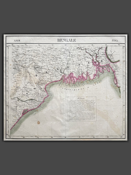

Original lithographed map by Philippe Vandermaelen (1795-1869)
An attractive map from Atlas Universel de Geographie depicts parts of present-day Bangladesh, Bihar, Orissa, West Bengal, and Tripura. This atlas was groundbreaking as the first to present all maps on a uniform scale of 1:1,641,836, with each map covering approximately 20 degrees of longitude (from Paris) and 6 degrees of latitude. Published between 1825 and 1827 in a single edition with 810 copies sold, it offered unprecedented detail for many regions, particularly the American West. The maps were hand-painted in outline colour, showcasing remarkable craftsmanship.
Philippe Marie Guillaume Vandermaelen (1795–1869), the Flemish cartographer behind this monumental work, was a native of Brussels and initially trained as a globe maker. His innovative vision of mapping on a universal scale was likely influenced by this early training. Beyond the Atlas Universel, Vandermaelen created globes, regional maps, a 250-sheet map of Belgium, and other significant works, establishing himself as a key figure in 19th-century cartography.
Image Size (cms): 49.5(H) x 57(W)
Image Size (inches): 19.5(H) x 22.5(W)
-
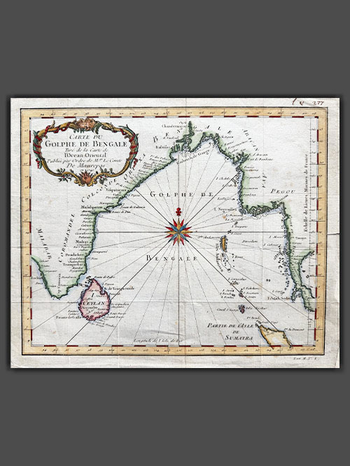

Original engraved plan by Jacques Nicholas Bellin (1703-1772)
This exquisite map by Jacques-Nicolas Bellin illustrates the Bay of Bengal during the height of French influence in India. Published in 1740, the map showcases coastal cities, islands, and regions of strategic and economic importance during a period when France nearly rivaled Britain as the dominant European power on the subcontinent.
The map highlights key coastal cities along the Bay of Bengal, including Pondicherry (Pondicheri) marked with a star, the capital of French India, which was central to French administration and trade. While overshadowed by British dominance, France’s influence in India was notable, with territories like Pondicherry, Yanam, Mahe, and Karikal. French ambitions, driven by competition with Britain, escalated in the mid-18th century under Joseph François Dupleix, leading to conflicts like the War of the Austrian Succession and the Seven Years’ War. Though the British defeated the French at the Battle of Plassey in 1757, France retained control of its coastal territories until India’s independence in 1947 and the formal transfer in 1962.
This map was meticulously crafted by Jacques-Nicolas Bellin and published as plate No. 1 in Volume 2 of the 1740 edition of Abbé Prévost’s L’Histoire Générale des Voyages. Bellin’s work, renowned for its precision and detail, is preserved in several libraries across Europe and North America, either as an individual map or as part of Prévost’s celebrated publication.
Image Size (cms): 23.5(H) x 28.5(W)
Image Size (inches): 9.5(H) x 11(W)
-
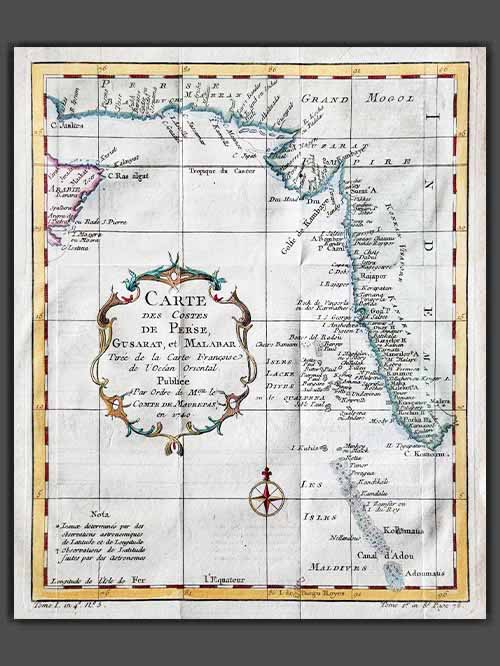

Original engraved plan by Jacques-Nicolas Bellin (1703–1772)
This decorative engraved map by Jacques-Nicolas Bellin appears in Abrégé de l’histoire générale des voyages, published in Paris in 1780. It depicts the region from the mouth of the Persian Gulf to the Maldives, showcasing all major ports and towns along this strategically significant area.
Jacques-Nicolas Bellin was a pivotal figure in 18th-century cartography, serving as Hydrographer to the French Navy and the first Ingénieur Hydrographe at the French Dépôt des cartes et plans de la Marine. Over a 50-year career, Bellin produced hundreds of maps and charts celebrated for their accuracy and functionality, setting a high standard in European cartography. His works included major sea atlases such as Neptune François (1753), Hydrographie Française (1756), and the comprehensive Petit Atlas Maritime (1764), featuring 580–581 finely detailed charts. Bellin also contributed extensively to Diderot’s Encyclopédie and Abbé Prévost’s Histoire Générale des Voyages. A child of the Enlightenment, Bellin prioritized scholarly precision and cited his sources diligently, distinguishing his work from the more decorative styles of earlier mapmakers. His contributions cemented France’s dominance in cartography and influenced his student, Rigobert Bonne, who succeeded him at the Dépôt.
Image Size (cms): 26(H) x 21(W)
Image Size (inches): 10(H) x 8.5(W)
-
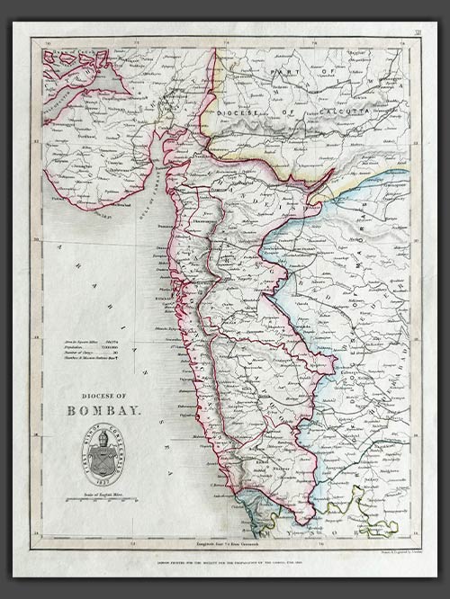

Original engraved map by J. Archer
from The Colonial Church Atlas
The Roman Catholic Archdiocese of Bombay is one of the most prominent Catholic jurisdictions in India, serving as the metropolitan see for the province of Bombay. Established as a vicariate in 1637 and elevated to an archdiocese in 1886, it encompasses Bombay and its surrounding areas. The Cathedral of the Holy Name in Colaba stands as its mother church.
The archdiocese is central to the spiritual, educational, and social fabric of the region’s Catholic community. Its extensive network includes parishes, schools, colleges, hospitals, and charitable organizations, which cater to people of all faiths. Known for its cultural and liturgical events, the Archdiocese of Bombay reflects the vibrancy and diversity of Mumbai’s Catholic population.
Size (cms): 30.5(H) x 23(W)
Size (inches): 12(H) x 9(W)
-

Original engraved map by A Dury (1766-1777)
This original, rare map of India, engraved by A. Dury (fl. 1766–1777), was published in 1761 as part of the A New General and Universal Atlas.
Dury was a British map and print publisher based in Duke’s Court on St. Martin’s Lane in London. Although he was a skilled mapmaker, he achieved less success than his contemporaries, such as Thomas Jefferys and William Faden, making his maps relatively rare. Dury is most commonly associated with the large Indian maps by James Rennell, one of his key collaborations. In addition, he produced notable maps during the Revolutionary War, including plans of Boston and Philadelphia, as well as a series related to the Russo-Turkish War of 1768–74. Despite his limited commercial success, Dury’s works remain valuable for their historical and cartographic significance.
Size (cms): 14.5(H) x 12.5(W)
Size (inches): 5.5(H) x 5(W)
-
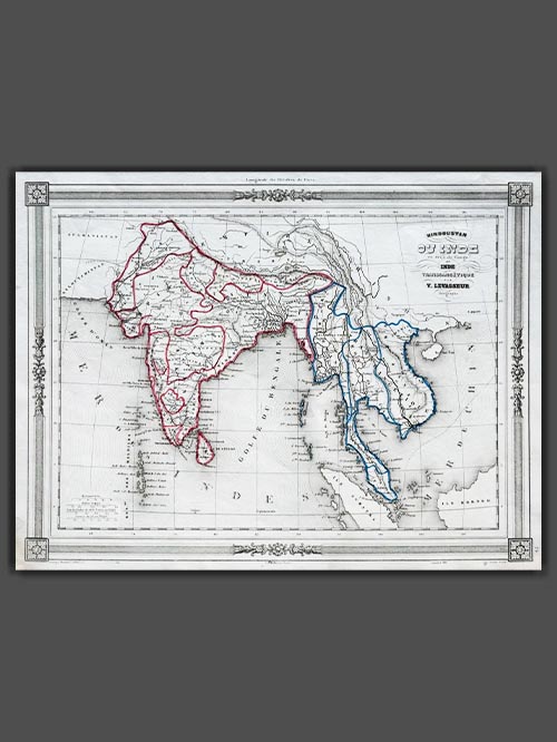

Original engraved map by V. Levasseur ( 1800-1870)
Victor Levasseur’s 1848 map of India and Southeast Asia, created for Maison Basset’s Atlas Illustré destiné à l’enseignement de la géographie élémentaire, offers a detailed and visually captivating depiction of the Indian subcontinent and surrounding regions. This finely engraved map provides extensive coverage of key areas, including India, Myanmar, Thailand, Vietnam, and the islands of Borneo and Sumatra.
Victor Levasseur was a renowned French engineer, cartographer, and engraver who made significant contributions to 19th-century cartography. He held several important political and educational positions related to cartography in France. Levasseur is best known for his Atlas National Illustré des 86 Départements et des Possessions de La France, a highly decorative atlas that includes his Planisphere and five notable continental maps.
Size (cms): 24.5(H) x 32.5(W)
Size (inches):9.5(H) x 13(W)
-
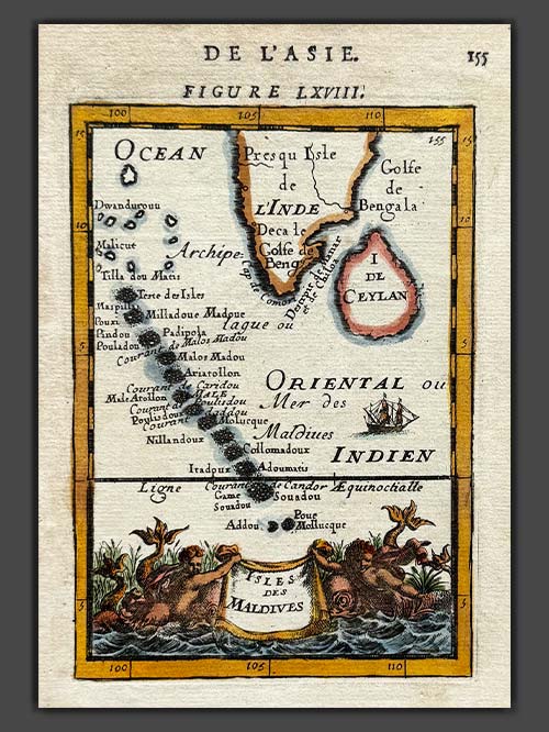

Original engraved map by A.M. Mallet (1630-1706)
This detailed map of the Maldives, southwest of the southern tip of India, showcases excellent detail and features a decorative title cartouche and vignette at the bottom. It originates from Mallet’s monumental Description de L’Univers, first published in Paris in 1683, regarded as one of the greatest works of its kind in the 17th century.
Alain Manesson Mallet (1630–1706), a French cartographer and engineer, began his career as a soldier in the army of Louis XIV, later becoming a Sergeant-Major in the artillery and an Inspector of Fortifications. He also served under the King of Portugal before returning to France, where he was appointed to the court of Louis XIV and taught mathematics. Mallet’s major publications include Description de L’Univers (1683) in five volumes, from which this map originates, and Les Travaux de Mars ou l’Art de la Guerre (1684) in three volumes.
Description de L’Univers encompasses a wide range of information, including star maps, maps of both the ancient and modern worlds, and a summary of the customs, religions, and governments of various nations. It is suggested that Mallet’s teaching background influenced his focus on entertaining readers, as reflected in the charming harbour scenes and rural landscapes he included beneath his descriptions of astronomical concepts and diagrams. Most of the figures engraved for this work were drawn by Mallet himself.
Size (cms): 17.5(H) x 13.5(W)
Size (inches): 7(H) x 5.5(W)
-

SOLD
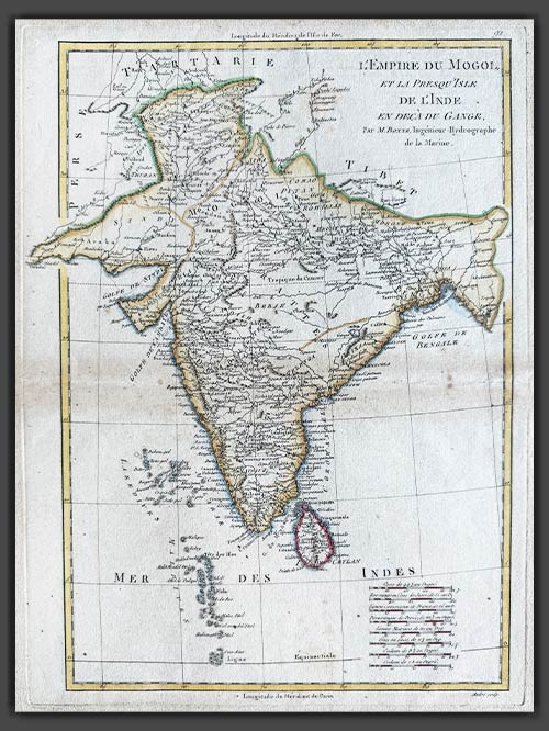
Original engraved map by Rigobert Bonne (1727-94)
This original copper-plate engraved map of India from the Mogul Empire in the north to the Ganges and south to Ceylon was published in Paris for the Atlas Supplement, circa 1787.
Bonne was a renowned French cartographer, recognised as one of the most significant figures in cartography during the late 18th century. In 1773, he succeeded Jacques Nicolas Bellin as Royal Cartographer to France, serving as Hydrographer at the Dépôt de la Marine. In this role, Bonne produced some of the most detailed and accurate maps of his era. His work marked a shift in cartographic style, moving away from the decorative designs of the 17th and early 18th centuries toward a more practical and detail-oriented approach. While retaining stylistic similarities to Bellin in terrain depiction, Bonne’s maps typically omitted decorative features like elaborate cartouches, hand coloring, and compass roses. Primarily focused on coastal regions, Bonne’s maps are highly esteemed for their precision, historical value, and aesthetic simplicity.
Image Size (cms): 37(H) x 27(W)
Image Size (inches): 14.5(H) x 10.5(W)
-
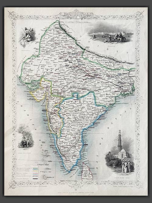

Pub. London
Original engraved map by J.Rapkin
This decorative map of British India, published in 1851 by John Tallis and Company, is a stunning example of 19th-century cartography. Engraved by John Rapkin, with vignettes by A.H. Wray and G. Greenbach, the map highlights the Madras, Calcutta, and Bombay Presidencies, as well as planned railway lines throughout the region. The decorative vignettes depict iconic landmarks such as Lahore, the Qutub Minar in Delhi, an Indian procession, and the Beloochees, all framed by an ornate flowered border.
Tallis and Company were map publishers based in London. They traded under various names including L.Tallis, John Tallis and John Tallis & Co.between 1838 and 1850. In 1851 their maps were published by the ‘London Printing and Publishing Co’., in both London and New York. Although he only issued one World Atlas, John Tallis, the founder of the firm, is among the best known of all map makers. The maps with small vignettes issued between 1850 and 1851 to commemorate the Great Exhibition in London are considered the last great series of decorative maps. They combine fine cartographical detail within an attractive border. Around the map there are several small but decorative vignettes depicting particular views, buildings, local inhabitants or the flora and fauna of that region.
Size (cms): 36(H) x 26(W)
Size (inches): 14(H) x 10(W)
-
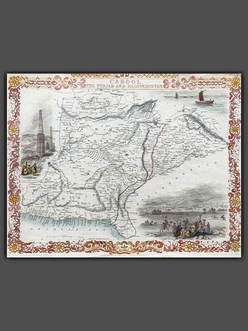

Pub. London
Original engraved map by J.Rapkin
This decorative engraved map by John Tallis, drawn by John Rapkin and published in 1851 for Tallis’s Illustrated Atlas and Modern History of the World, depicts present-day Afghanistan and Pakistan. Renowned for its artistic details, the map features decorative vignettes of regional landmarks, including boats on the Indus River, the city of Lahore, and the fortress and minarets of Ghazni, showcasing the cultural and architectural heritage of the region. Created during the era of the First Anglo-Afghan War (1839–1842) and the “Great Game” rivalry between Britain and Russia, this map highlights the geopolitical significance of the region.
Tallis and Company were map publishers based in London. They traded under various names including L.Tallis, John Tallis and John Tallis & Co.between 1838 and 1850. In 1851 their maps were published by the ‘London Printing and Publishing Co’., in both London and New York. Although he only issued one World Atlas, John Tallis, the founder of the firm, is among the best known of all map makers. The maps with small vignettes issued between 1850 and 1851 to commemorate the Great Exhibition in London are considered the last great series of decorative maps. They combine fine cartographical detail within an attractive border. Around the map there are several small but decorative vignettes depicting particular views, buildings, local inhabitants or the flora and fauna of that region.
Size (cms): 26.5(H) x 35(W)
Size (inches): 10.5(H) x 14(W)
-
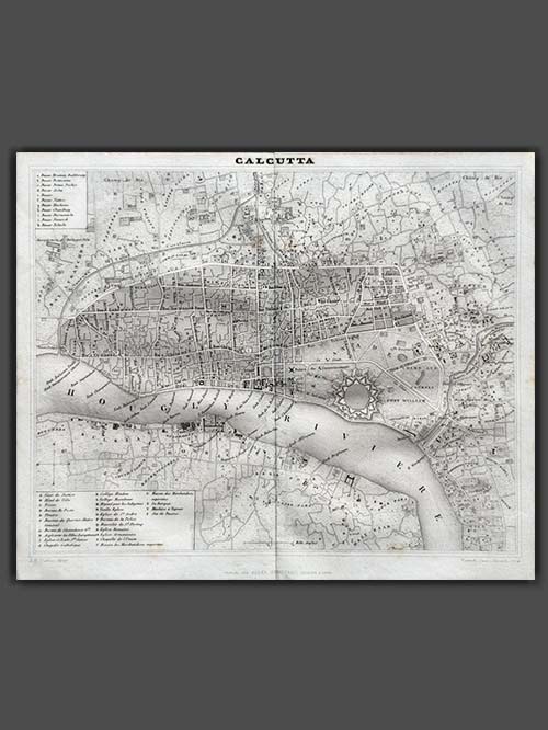

Original engraved map by Jules Renouard
Finely engraved Map of Calcutta by Jules Renouard, published in Paris circa 1839, showcasing a detailed city plan with Fort William on the Hooghly River and its surrounding areas. The map includes two inset keys identifying prominent historical buildings.
Jules Renouard (1798–1854) was a prominent French book dealer, editor, publisher, and bibliographer. Born in Paris to revolutionary and book dealer Antoine-Augustin Renouard, he studied at the Lycée Louis-le-Grand before briefly pursuing banking in London. In 1826, he inherited his father’s book business and became a key figure in the trade. Renouard co-founded the Cercle de la Librairie (Book Dealers’ Association) in 1847.
Image Size (cms): 22.5(H) x 26.5(W)
Image Size (inches): 9(H) x 10.5(W)
-
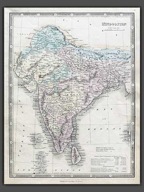

Original engraved map by George Philip & Son
Detailed map of India with two inset cartouches of area and population of the British states and the foreign possessions namely the Portuguese, Dutch, French and Danish. It was published by George Philip & Son in Liverpool circa 1858.
George Philip (1800–1882) was a Scottish map publisher and cartographer who founded his own firm in Liverpool in 1834 after apprenticing with a printer and bookseller. Initially focusing on educational materials, he collaborated with noted cartographers like John Bartholomew Sr. and August Petermann. In 1848, he brought his son, George Philip Jr. (1823–1902), into the business, renaming it George Philip & Son Ltd. Under George Jr., the company became a major publishing house and later established the London Geographical Institute, embracing modern printing techniques to produce high-quality, affordable maps on a large scale.
Image Size (cms): 32(H) x 24.5(W)
Image Size (inches): 12.5(H) x 9.5(W)

