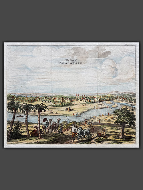
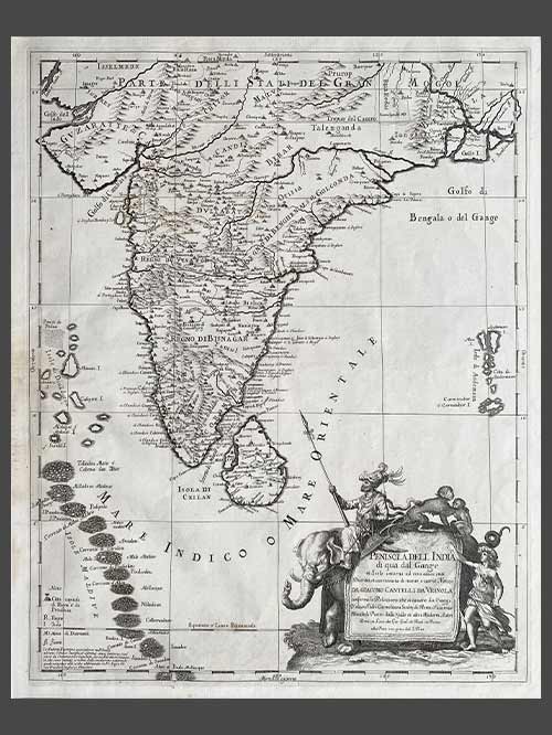
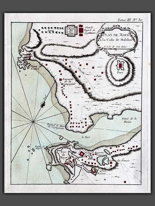
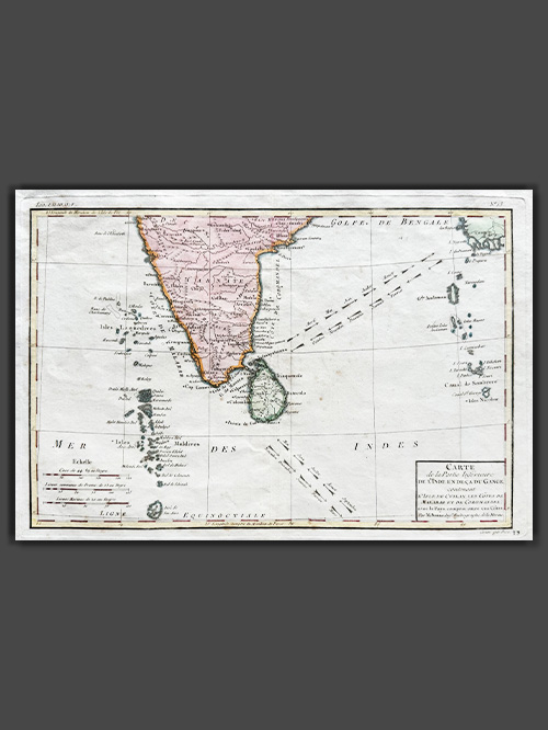
Filter products Showing 145 - 160 of 169 results
Sort By
Show Per Page
Filter products Showing 145 - 160 of 169 results
Sort By
Show Per Page
  • peninsular of indiapeninsular of india

    Peninsular of India

    Pub. Rome by Giacomo Giovanni Rossi

    Original engraved map

    The scarce decorative map of India, Ceylon, the Maldives, and neighbouring regions, created by Cantelli da Vignola and published in Rome by Rossi, offers one of the most detailed depictions of the area from that period. It features an ornate cartouche adorned with an elephant. The map was published in the ‘Mercurio geografico’ collection of maps, published between 1660 and 1730 by the De Rossi typography. The maps in the collection are exquisitely copied and engraved by renowned artisans of the time and also include works of esteemed cartographers such as Michele Antonio Baudrand, Nicolas Sanson and Giovanni Antonio Magini.

    Cantelli, a geographer and cartographer from Montorsello near Vignola, began his journey in Bologna, where he pursued humanistic studies. In 1669, he became the secretary to Marquis Obizzo da Ferrara before traveling to Venice and eventually Paris. There, he established connections with prominent French geographers of the time, including Du Val, Nicola Sanson, and Michel Antoine Baudrand. Cantelli collaborated with the renowned De Rossi cartographic workshop, which published most of his maps. With a growing reputation as a skilled cartographer, Cantelli caught the attention of Pope Innocent XI and the Duke of Modena and Reggio Francesco II d’Este, both of whom sought him as their official cartographer. He chose to work for Francesco II and was appointed court geographer in November 1685. Over the following years, he produced numerous maps of European countries and territories. The majority of his maps were featured in the well-known Mercurio Geografico atlas, published in Rome by the De Rossi family.

    Size (cms): 55(H) x 44(W)
    Size (inches): 21.5(H) x 17.5(W)

    Mounted Size (cms): 75(H) x 64(W)
    Mounted Size (inches): 29.5(H) x 25(W)

  • Pichhwai for Gopashtami

    Nathdwara (Rajasthan)

    Cotton, painted on pigments

    An attractive small Pichhwai depicting eight white cows grouped in a meadow with a lotus and fish filled stream in the foreground. The cows are bedecked and have henna on their horns and hooves. Large handprints painted in saffron henna cover bodies. A floral border surrounds the panel. This pichhwai would have either accompanied a larger pichhwai in a prominent shrine or constituted part of a small domestic shrine.

    Gopashtami is a festival that commemorates Krishna’s elevation from a young herder of calves to full cowherd. Krishna grows into the perfect cowherd, the one all the cows heed, answering to the golden strains of his flute. At Nathdwara the cows, decked in their finest, are brought into the haveli. There is a playful spirit about this festival that is well expressed in this pichhwai. The cows, gentle creatures with limpid eyes and expressive ears, are constant reminders of Vraja and Krishna’s childhood occupation as cowherd.

    Size (cms): 75(H) x 124(W)
    Size (inches): 29.5(H) x 49(W)

  • pichhwai of sapta swarupa annakutotsavapichhwai of sapta swarupa annakutotsava

    Pichhwai of Sapta Swarupa Annakutotsava

    Nathdwara (Rajasthan)

    Cotton, painted on pigments

    A scarce small Pichhwai celebrating Sapta Swarupa Annakutotsava, with the central figure of Srinathji accompanied by his seven forms (Sapta Swarupa) and attended by two goswamis. Srinathji and the sath swarupa, are all richly adorned and bejewelled and they stand upon an elevated altar in front of a saffron covered thada vastra. A richly embroidered tree-of-life hanging encrusted with jewels and pearls is placed behind the shrine.

    A veritable feast of chhappan bhoga (fifty-six offerings) in the form of large mounds of rice and curd, festooned with pink sweet meats are laid out in front of Srinathji. These offering commemorate the grand festival of Annakuta, the largest yearly festival celebrated at Nathdwara, which is held the day after Diwali. The festival is celebrated in recognition of an episode in the life of Krishna when he persuaded the villagers of Vraj to present their harvest offerings to the spirit of Mount Govardhana, instead of Indra. The mountains of rice symbolically represent Mount Govardhana which are topped by a sweet cake called gunja representing the head of Vishnu flanked by four more signifying the four ayudhyas or weapons of Vishnu.

    The pichhwai is bordered by bands depicting Srinatji in twenty-four different Darshan attires on its sides and top and a row of nandis (cows) above a lotus filled lake below.

    Size (cms): 81(H) x 59(W)
    Size (inches): 32(H) x 23(W)

  • plan de andarajapourplan de andarajapour

    Plan de Andarajapour

    Original engraved plan by Jacques-Nicolas Bellin (1703–1772)

    This finely engraved map depicts Andarajapour (also known as Rajapur), taken from Jacques-Nicolas Bellin’s Le Petit Atlas Maritime, first published in Paris in 1764. Rajapur, a small yet historically significant port on Maharashtra’s Konkan coast, was a vital maritime center during the Bijapur Sultanate, benefiting from a navigable creek that connected it to the Arabian Sea. In 1668, under Shivaji’s reign, the French East India Company was granted permission to establish a factory in Rajapur, aiming to capitalize on the export of spices and textiles.

    Jacques-Nicolas Bellin was a pivotal figure in 18th-century cartography, serving as Hydrographer to the French Navy and the first Ingénieur Hydrographe at the French Dépôt des cartes et plans de la Marine. Over a 50-year career, Bellin produced hundreds of maps and charts celebrated for their accuracy and functionality, setting a high standard in European cartography. His works included major sea atlases such as Neptune François (1753), Hydrographie Française (1756), and the comprehensive Petit Atlas Maritime (1764), featuring 580–581 finely detailed charts. Bellin also contributed extensively to Diderot’s Encyclopédie and Abbé Prévost’s Histoire Générale des Voyages. A child of the Enlightenment, Bellin prioritized scholarly precision and cited his sources diligently, distinguishing his work from the more decorative styles of earlier mapmakers. His contributions cemented France’s dominance in cartography and influenced his student, Rigobert Bonne, who succeeded him at the Dépôt.

    Image Size (cms): 24(H) x 19(W)
    Image Size (inches): 9.5(H) x 7.5(W)
  • plan de goaplan de goa

    Plan de Goa

    Original engraved plan by Jacques-Nicolas Bellin (1703–1772)

    A detailed city map of Old Goa, situated on the banks of the Mandovi River in India. The map features a decorative cartouche, a coat of arms, and ships offshore, reflecting Goa’s historical significance as a maritime and cultural hub during the Portuguese era. Goa was seized by Afonso de Albuquerque in 1510 and became a key hub for maritime trade with Africa, the Persian Gulf, and Asia, forming part of a triangular trade network with Macau and Nagasaki. It also served as the Jesuit Order’s eastern headquarters under St. Francis Xavier. Renowned for its architecture, including the Viceroy’s Palace and Se Cathedral, Goa flourished as a commercial and religious center. Despite challenges from rising Dutch power, Goa remained the “Golden City” of Portuguese controlled Asia.

    Jacques-Nicolas Bellin was a pivotal figure in 18th-century cartography, serving as Hydrographer to the French Navy and the first Ingénieur Hydrographe at the French Dépôt des cartes et plans de la Marine. Over a 50-year career, Bellin produced hundreds of maps and charts celebrated for their accuracy and functionality, setting a high standard in European cartography. His works included major sea atlases such as Neptune François (1753), Hydrographie Française (1756), and the comprehensive Petit Atlas Maritime (1764), featuring 580–581 finely detailed charts. Bellin also contributed extensively to Diderot’s Encyclopédie and Abbé Prévost’s Histoire Générale des Voyages. A child of the Enlightenment, Bellin prioritized scholarly precision and cited his sources diligently, distinguishing his work from the more decorative styles of earlier mapmakers. His contributions cemented France’s dominance in cartography and influenced his student, Rigobert Bonne, who succeeded him at the Dépôt.

    Image Size (cms): 23(H) x 35.5(W)
    Image Size (inches): 9(H) x 14(W)
  • plan de mayeplan de maye

    Plan de Maye

    Original engraved plan by Jacques-Nicolas Bellin (1703–1772)

    This finely engraved plan depicts Mayyazhi (also known as Mahé), taken from Jacques Nicolas Bellin’s Le Petit Atlas Maritime, first published in Paris in 1764. Situated at the mouth of the Mayyazhi River in southern coastal India, Mahé retains a significant French colonial heritage, visible even today. The colonial legacy is evident in this map, with several landmarks identified as belonging to the French East India Company, alongside notable structures such as a French church.

    Jacques-Nicolas Bellin was a pivotal figure in 18th-century cartography, serving as Hydrographer to the French Navy and the first Ingénieur Hydrographe at the French Dépôt des cartes et plans de la Marine. Over a 50-year career, Bellin produced hundreds of maps and charts celebrated for their accuracy and functionality, setting a high standard in European cartography. His works included major sea atlases such as Neptune François (1753), Hydrographie Française (1756), and the comprehensive Petit Atlas Maritime (1764), featuring 580–581 finely detailed charts. Bellin also contributed extensively to Diderot’s Encyclopédie and Abbé Prévost’s Histoire Générale des Voyages. A child of the Enlightenment, Bellin prioritized scholarly precision and cited his sources diligently, distinguishing his work from the more decorative styles of earlier mapmakers. His contributions cemented France’s dominance in cartography and influenced his student, Rigobert Bonne, who succeeded him at the Dépôt.

    Image Size (cms): 24(H) x 19(W)
    Image Size (inches): 9.5(H) x 7.5(W)
  • plan of cowlangplan of cowlang

    Plan of Cowlang

    Original engraved plan by Philippus Baldaeus (1632-1672)

    This original engraved plan by Philippus Baldaeus (1632–1672) appears in Naauwkeurige Beschryvinge van Malabar en Choromandel (1672) and was re-issued in A Collection of Voyages & Travels (1704–52). Baldaeus, a Dutch Reformed Church minister, served in the Dutch East Indies and documented South India and Ceylon’s culture, history, and religion. Fluent in Tamil, Portuguese, and Sanskrit, he was among the first Europeans to extensively write about Hinduism, introducing Indian mythology, the Ramayana, and the Mahabharata to European audiences.

    Quilon (Cowlang or Kollam), one of the oldest ports on Kerala’s Malabar Coast, has a rich history of maritime trade dating back to the Phoenicians, Romans, and Chinese. By the 9th century, it became a major trade hub, exporting spices, pearls, sapphires, and silk. The Portuguese fortified it in the 16th century, but by 1661, the Dutch took control, restructuring trade networks and exporting pepper and coir. The Dutch fort played a key role until the British took over in the late 18th century.

    Dutch India (1605–1825) comprised regions like Dutch Ceylon, Coromandel, Malabar, Bengal, and Suratte. The Dutch East India Company traded textiles, spices, precious stones, indigo, silk, and pepper, with notable mints in Cochin, Negapatam, and Pulicat. However, the Dutch influence waned after the 1741 Battle of Colachel, and their remaining territories were ceded to the British under the Anglo-Dutch Treaty of 1824, marking the end of their presence in India.

    Image Size (cms): 30(H) x 37(W)
    Image Size (inches): 12(H) x 14.5(W)
  • plan of cranganoreplan of cranganore

    Plan of Cranganore

    Original engraved plan by Philippus Baldaeus (1632-1672)

    This original engraved plan by Philippus Baldaeus (1632-1672) appears in Naauwkeurige Beschryvinge van Malabar en Choromandel (1672) and was re-issued in A Collection of Voyages & Travels (1704–52). Baldaeus, a Dutch Reformed Church minister, served in the Dutch East Indies and documented South India and Ceylon’s culture, history, and religion. Fluent in Tamil, Portuguese, and Sanskrit, he was among the first Europeans to extensively write about Hinduism, introducing Indian mythology, the Ramayana, and the Mahabharata to European audiences.

    Cranganore, once part of the Later Chera dynasty’s capital Mahodayapuram, was a key trade hub connected to the Roman Empire through the nearby port of Muziris, exporting goods like pepper, pearls, and ivory. It later became a tributary state under the Zamorin of Calicut and faced conflicts with the Kingdom of Cochin. The Portuguese destroyed it in 1504, the Dutch captured it in 1663, and in 1789, they sold it to the Kingdom of Travancore, ending their influence in the region.

    Dutch India (1605–1825) comprised regions like Dutch Ceylon, Coromandel, Malabar, Bengal, and Suratte. The Dutch East India Company traded textiles, spices, precious stones, indigo, silk, and pepper, with notable mints in Cochin, Negapatam, and Pulicat. However, the Dutch influence waned after the 1741 Battle of Colachel, and their remaining territories were ceded to the British under the Anglo-Dutch Treaty of 1824, marking the end of their presence in India.

    Image Size (cms): 29(H) x 37(W)
    Image Size (inches): 11.5(H) x 14.5(W)
  • plan of fort geldria in pellacataplan of fort geldria in pellacata

    Plan of Fort Geldria in Pellacata

    Original engraved plan by Phillipus Baldaeus (1632-1672)

    This original engraved plan by Phillipus Baldaeus (1632–1672) appears in Naauwkeurige Beschryvinge van Malabar en Choromandel (1672) and was re-issued in A Collection of Voyages & Travels (1704–52). Baldaeus, a Dutch Reformed Church minister, served in the Dutch East Indies and documented South India and Ceylon’s culture, history, and religion. Fluent in Tamil, Portuguese, and Sanskrit, he was among the first Europeans to extensively write about Hinduism, introducing Indian mythology, the Ramayana, and the Mahabharata to European audiences.

    Pulicat (Pellacata), located at the mouth of Pulicat Lake in Tamil Nadu, was a prominent seaport with a history dating back to 300 BCE. Controlled by various rulers, including Arabs, Portuguese, Dutch, and British, it became a multicultural hub with over 50,000 people in the 16th century. The Dutch established Fort Geldria in 1613, making it their stronghold until 1690. Pulicat later regained importance after 1781 and became a major center for cotton trade and the Dutch slave trade, with over 38,000 slaves shipped from its ports between 1621 and 1665.

    Dutch India (1605–1825) comprised regions like Dutch Ceylon, Coromandel, Malabar, Bengal, and Suratte. The Dutch East India Company traded textiles, spices, precious stones, indigo, silk, and pepper, with notable mints in Cochin, Negapatam, and Pulicat. However, the Dutch influence waned after the 1741 Battle of Colachel, and their remaining territories were ceded to the British under the Anglo-Dutch Treaty of 1824, marking the end of their presence in India.

    Image Size (cms): 30(H) x 38(W)
    Image Size (inches): 12(H) x 15(W)
  • plan of negapatamplan of negapatam

    Plan of Negapatam

    Original engraved plan by Philippus Baldaeus (1632-1672)

    This original engraved plan by Philippus Baldaeus (1632–1672) appears in Naauwkeurige Beschryvinge van Malabar en Choromandel (1672) and was re-issued in A Collection of Voyages & Travels (1704–52). Baldaeus, a Dutch Reformed Church minister, served in the Dutch East Indies and documented South India and Ceylon’s culture, history, and religion. Fluent in Tamil, Portuguese, and Sanskrit, he was among the first Europeans to extensively write about Hinduism, introducing Indian mythology, the Ramayana, and the Mahabharata to European audiences.

    Negapatam, a prominent Chola port from the 9th–12th century, housed the Chudamani Vihara, a significant Buddhist structure built by the Sri Lankan king with Chola support. The Portuguese later settled here, followed by the Dutch, who made it the capital of Dutch Coromandel (1660–1781). It came under British control in 1781 and served as Tanjore district’s capital under the Madras Presidency (1799–1845).

    Dutch India (1605–1825) comprised regions like Dutch Ceylon, Coromandel, Malabar, Bengal, and Suratte. The Dutch East India Company traded textiles, spices, precious stones, indigo, silk, and pepper, with notable mints in Cochin, Negapatam, and Pulicat. However, the Dutch influence waned after the 1741 Battle of Colachel, and their remaining territories were ceded to the British under the Anglo-Dutch Treaty of 1824, marking the end of their presence in India.

    Image Size (cms): 38(H) x 31(W)
    Image Size (inches): 15(H) x 12(W)
  • plan of pellacataplan of pellacata

    Plan of Pellacata

    Original engraved plan by Philippus Baldaeus (1632-1672)

    This original engraved plan by Philippus Baldaeus (1632–1672) appears in Naauwkeurige Beschryvinge van Malabar en Choromandel (1672) and was re-issued in A Collection of Voyages & Travels (1704–52). Baldaeus, a Dutch Reformed Church minister, served in the Dutch East Indies and documented South India and Ceylon’s culture, history, and religion. Fluent in Tamil, Portuguese, and Sanskrit, he was among the first Europeans to extensively write about Hinduism, introducing Indian mythology, the Ramayana, and the Mahabharata to European audiences.

    Pulicat (Pellacata), located at the mouth of Pulicat Lake in Tamil Nadu, was a prominent seaport with a history dating back to 300 BCE. Controlled by various rulers, including Arabs, Portuguese, Dutch, and British, it became a multicultural hub with over 50,000 people in the 16th century. The Dutch established Fort Geldria in 1613, making it their stronghold until 1690. Pulicat later regained importance after 1781 and became a major center for cotton trade and the Dutch slave trade, with over 38,000 slaves shipped from its ports between 1621 and 1665.

    Dutch India (1605–1825) comprised regions like Dutch Ceylon, Coromandel, Malabar, Bengal, and Suratte. The Dutch East India Company traded textiles, spices, precious stones, indigo, silk, and pepper, with notable mints in Cochin, Negapatam, and Pulicat. However, the Dutch influence waned after the 1741 Battle of Colachel, and their remaining territories were ceded to the British under the Anglo-Dutch Treaty of 1824, marking the end of their presence in India.

    Image Size (cms): 29.5(H) x 37.5(W)
    Image Size (inches): 11.5(H) x 15(W)
  • plan of tutecorynplan of tutecoryn

    Plan of Tutecoryn

    Original engraved plan by Philippus Baldaeus (1632-1672)

    This original engraved plan by Philippus Baldaeus (1632-1672) appears in Naauwkeurige Beschryvinge van Malabar en Choromandel (1672) and was re-issued in A Collection of Voyages & Travels (1704–52). Baldaeus, a Dutch Reformed Church minister, served in the Dutch East Indies and documented South India and Ceylon’s culture, history, and religion. Fluent in Tamil, Portuguese, and Sanskrit, he was among the first Europeans to extensively write about Hinduism, introducing Indian mythology, the Ramayana, and the Mahabharata to European audiences.

    Tutecoryn, known as the “Pearl City,” has been a major seaport since the 6th century, serving as a gateway to Tamil Nadu and Southern India. The town’s rulers over centuries included the Pandyas, Cholas, Ma’bar Sultanate, Vijayanagar Empire, Nayaks, and various colonial powers such as the Portuguese, Dutch, and British East India Company. The town’s pearl fishing and maritime trade brought it global recognition, making it an essential node for commerce and culture.

    Dutch India (1605–1825) comprised regions like Dutch Ceylon, Coromandel, Malabar, Bengal, and Suratte. The Dutch East India Company traded textiles, spices, precious stones, indigo, silk, and pepper, with notable mints in Cochin, Negapatam, and Pulicat. However, the Dutch influence waned after the 1741 Battle of Colachel, and their remaining territories were ceded to the British under the Anglo-Dutch Treaty of 1824, marking the end of their presence in India.

    Image Size (cms): 30.5(H) x 37.5(W)
    Image Size (inches): 12(H) x 15(W)
  • l'inde de ca le gange (copy)l'inde de ca le gange (copy)

    South India

    Original engraved map by Pieter van den aa (1659-1733)

    This map, created by Rigobert Bonne and G. Raynal in 1784, depicts Southern India, Sri Lanka, the Maldives, and the Andaman and Nicobar Islands. It includes arrows indicating the direction of trade winds across the Indian Ocean, showing seasonal patterns. The map is highly detailed, displaying towns, rivers, topographical features, ports, and political boundaries. It was part of G. Raynal’s Atlas de Toutes les Parties Connues du Globe Terrestre, published alongside L’Histoire Philosophique et Politique des Établissemens et du Commerce des Européens dans les Deux Indes.

    Bonne (1727–1794) was a notable French cartographer, mathematician, and engineer, renowned for his accurate and detailed maps. Succeeding Jacques-Nicolas Bellin as Royal Cartographer to France in 1773, he was a key figure in the shift from decorative cartography to a more scientific approach. His work, especially focusing on coastal regions, is admired for both its precision and aesthetic quality.

    Image Size (cms): 23.5(H) x 34(W)
    Image Size (inches): 9.5(H) x 13.5(W)

  • view of ahmedabadview of ahmedabad

    View of Ahmedabad

    Original engraved plan by Phillipus Baldaeus (1632-1672)

    This original engraved plan by Phillipus Baldaeus (1632–1672) appears in Naauwkeurige Beschryvinge van Malabar en Choromandel (1672) and was re-issued in A Collection of Voyages & Travels (1704–52). Baldaeus, a Dutch Reformed Church minister, served in the Dutch East Indies and documented South India and Ceylon’s culture, history, and religion. Fluent in Tamil, Portuguese, and Sanskrit, he was among the first Europeans to extensively write about Hinduism, introducing Indian mythology, the Ramayana, and the Mahabharata to European audiences.

    Ahmedabad, Gujarat’s largest city, is located along the Sabarmati River in western India. Established in 1411, by Ahmed Shah I of the Gujarat Sultanate, it became a political and economic center. While its origins trace back to the 12th century under the Solanki dynasty, the city thrived during the Sultanate (1411–1511) and experienced renewed prosperity under Mughal rule (1572–1707). Once hailed as ‘the greatest city in India,’ Ahmedabad was renowned for its rich silks and gold-embroidered textiles, attracting traders like the Dutch and English.

    The Dutch East India Company (VOC) played a significant role in Ahmedabad’s history from 1615 to 1744. They established the Dutch Factory, or ‘Dutch Haveli,’ in 1617, a complex inspired by Indo-Islamic and Mughal architecture with elegant arches and asymmetrical wings. The factory was a hub for trading cotton, indigo, and silk yarn. Additionally, the Dutch cemetery in Ahmedabad remains a historical marker of their influence and the lives of those who settled in the city.

    Image Size (cms): 30(H) x 37(W)
    Image Size (inches): 12(H) x 14.5(W)
  • Ganesha with Lakshmi and Saraswati

    Tamil Nadu (South India)

    silver repoussé on velvet 

    Ganesha, four armed, is seated cross legged on a lotus throne. He carries a mace, a noose, a ball of modak and his broken tusks in his four hands. Directly above is the figure of a single winged angel with stylised wings. He is flanked by the figures of Lakshmi and Saraswati, each seated on their lotus thrones. The deities appear to float on the waves of the cosmic ocean.

    Framed Size (cms): 42 (H) x 54 (W)
    Framed Size (inches): 16.5 (H) x 21 (W)

  • Crocodile Puppet

    Andhra Pradesh (South India)

    Framed Leather Shadow Puppet

    In Andhra Pradesh the Tholu Bomalatta tradition of travelling shadow puppet theatre typically enacts the voluminous epics, Ramayana and Mahabharata. Made from goat, cow or buffalo skin, the Andhra Pradesh puppets are sometimes more than five feet high. They are translucent, stained in vegetable dyes and are extremely stylised in facial garment rendering. Viewed as shadows from behind a lamp-lit cloth screen, the puppets are manipulated with the help of bamboo sticks at certain points, usually at the joints on the shoulders, knees, elbows and head. The highly animated performance, along with the drum beat and loud narration of stories is highly effective in mesmerising the spectators transporting them into another world.

    Size (cms): 81.3(H) x 160(W)
    Size (inches): 32(H) x 63(W)