
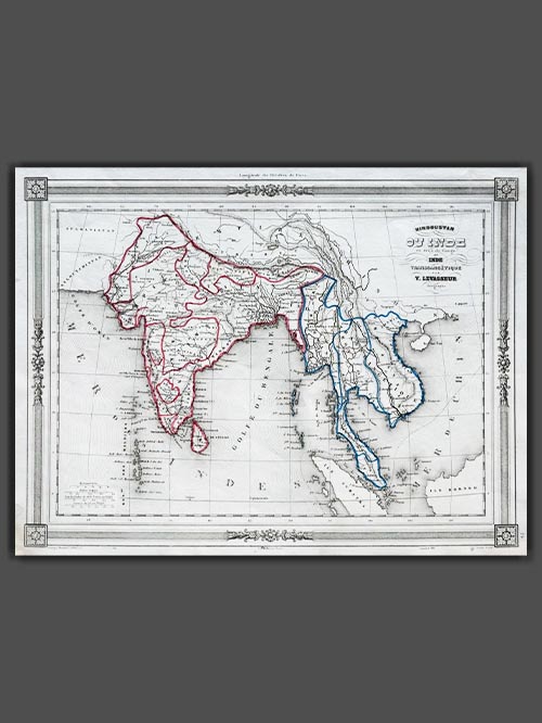
Hindoustan ou Inde
Original engraved map by V. Levasseur ( 1800-1870)
Size (cms): 24.5(H) x 32.5(W)
Size (inches):9.5(H) x 13(W)

Original engraved map by V. Levasseur ( 1800-1870)
Victor Levasseur’s 1848 map of India and Southeast Asia, created for Maison Basset’s Atlas Illustré destiné à l’enseignement de la géographie élémentaire, offers a detailed and visually captivating depiction of the Indian subcontinent and surrounding regions. This finely engraved map provides extensive coverage of key areas, including India, Myanmar, Thailand, Vietnam, and the islands of Borneo and Sumatra.
Victor Levasseur was a renowned French engineer, cartographer, and engraver who made significant contributions to 19th-century cartography. He held several important political and educational positions related to cartography in France. Levasseur is best known for his Atlas National Illustré des 86 Départements et des Possessions de La France, a highly decorative atlas that includes his Planisphere and five notable continental maps.
Size (cms): 24.5(H) x 32.5(W)
Size (inches):9.5(H) x 13(W)
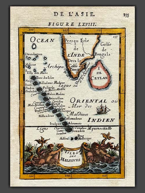

Original engraved map by A.M. Mallet (1630-1706)
This detailed map of the Maldives, southwest of the southern tip of India, showcases excellent detail and features a decorative title cartouche and vignette at the bottom. It originates from Mallet’s monumental Description de L’Univers, first published in Paris in 1683, regarded as one of the greatest works of its kind in the 17th century.
Alain Manesson Mallet (1630–1706), a French cartographer and engineer, began his career as a soldier in the army of Louis XIV, later becoming a Sergeant-Major in the artillery and an Inspector of Fortifications. He also served under the King of Portugal before returning to France, where he was appointed to the court of Louis XIV and taught mathematics. Mallet’s major publications include Description de L’Univers (1683) in five volumes, from which this map originates, and Les Travaux de Mars ou l’Art de la Guerre (1684) in three volumes.
Description de L’Univers encompasses a wide range of information, including star maps, maps of both the ancient and modern worlds, and a summary of the customs, religions, and governments of various nations. It is suggested that Mallet’s teaching background influenced his focus on entertaining readers, as reflected in the charming harbour scenes and rural landscapes he included beneath his descriptions of astronomical concepts and diagrams. Most of the figures engraved for this work were drawn by Mallet himself.
Size (cms): 17.5(H) x 13.5(W)
Size (inches): 7(H) x 5.5(W)

SOLD
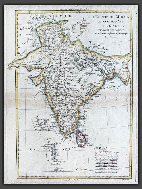
Original engraved map by Rigobert Bonne (1727-94)
This original copper-plate engraved map of India from the Mogul Empire in the north to the Ganges and south to Ceylon was published in Paris for the Atlas Supplement, circa 1787.
Bonne was a renowned French cartographer, recognised as one of the most significant figures in cartography during the late 18th century. In 1773, he succeeded Jacques Nicolas Bellin as Royal Cartographer to France, serving as Hydrographer at the Dépôt de la Marine. In this role, Bonne produced some of the most detailed and accurate maps of his era. His work marked a shift in cartographic style, moving away from the decorative designs of the 17th and early 18th centuries toward a more practical and detail-oriented approach. While retaining stylistic similarities to Bellin in terrain depiction, Bonne’s maps typically omitted decorative features like elaborate cartouches, hand coloring, and compass roses. Primarily focused on coastal regions, Bonne’s maps are highly esteemed for their precision, historical value, and aesthetic simplicity.
Image Size (cms): 37(H) x 27(W)
Image Size (inches): 14.5(H) x 10.5(W)
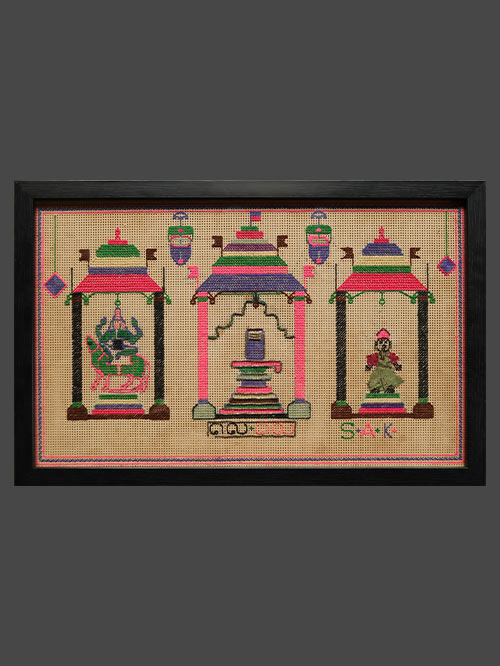

Chettinad (Tamil Nadu)
cross stitch embroidery
This decorative cross stitch embroidery artwork depicts three pillared niches, the central larger one with lingam flanked by two smaller ones with Ganesha and Kartikeya, temple lamps suspended above.
Framed Size (cms): 32(H) x 49(W)
Framed Size (inches): 12.5(H) x 19.5(W)
")
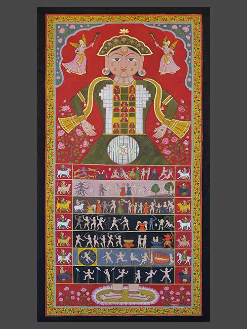
Rajasthan
Opaque watercolour on cloth with highlights in gold
The Lokapurusha is a symbolic representation of a cosmic being, encapsulating the entire universe within the form of a human figure. In this portrayal, the figure takes on a female form adorned with a shawl, earrings, and a gold crown. The cheeks depict the palaces of the five most perfect gods. The lower world, adholoka, resides in the wide skirt, housing seven infernal levels where souls undergo suffering for bad karma. The middle world, madhyaloka, is at the figure’s waist, represented as a disk with concentric circles illustrating continents and oceans. The upper world, urdhvaloka, occupies the torso and head, hosting gods, demigods, planets, and stars. A crescent moon on the forehead signifies the realm of Liberated souls, free from the cycle of rebirth. Jainism, with roots in Vedic times, uses numerical and schematic representations, such as those found in texts like Sangrahanisutra and Laghukshetrasamasa, to address existential questions about life, death, and the soul’s existence.
Size (cms): 136(H) x 68(W)
Size (inches): 53.5(H) x 27(W)
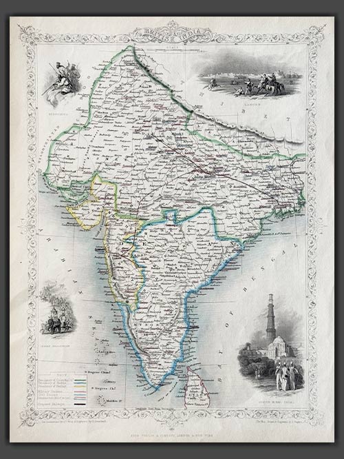

Pub. London
Original engraved map by J.Rapkin
This decorative map of British India, published in 1851 by John Tallis and Company, is a stunning example of 19th-century cartography. Engraved by John Rapkin, with vignettes by A.H. Wray and G. Greenbach, the map highlights the Madras, Calcutta, and Bombay Presidencies, as well as planned railway lines throughout the region. The decorative vignettes depict iconic landmarks such as Lahore, the Qutub Minar in Delhi, an Indian procession, and the Beloochees, all framed by an ornate flowered border.
Tallis and Company were map publishers based in London. They traded under various names including L.Tallis, John Tallis and John Tallis & Co.between 1838 and 1850. In 1851 their maps were published by the ‘London Printing and Publishing Co’., in both London and New York. Although he only issued one World Atlas, John Tallis, the founder of the firm, is among the best known of all map makers. The maps with small vignettes issued between 1850 and 1851 to commemorate the Great Exhibition in London are considered the last great series of decorative maps. They combine fine cartographical detail within an attractive border. Around the map there are several small but decorative vignettes depicting particular views, buildings, local inhabitants or the flora and fauna of that region.
Size (cms): 36(H) x 26(W)
Size (inches): 14(H) x 10(W)
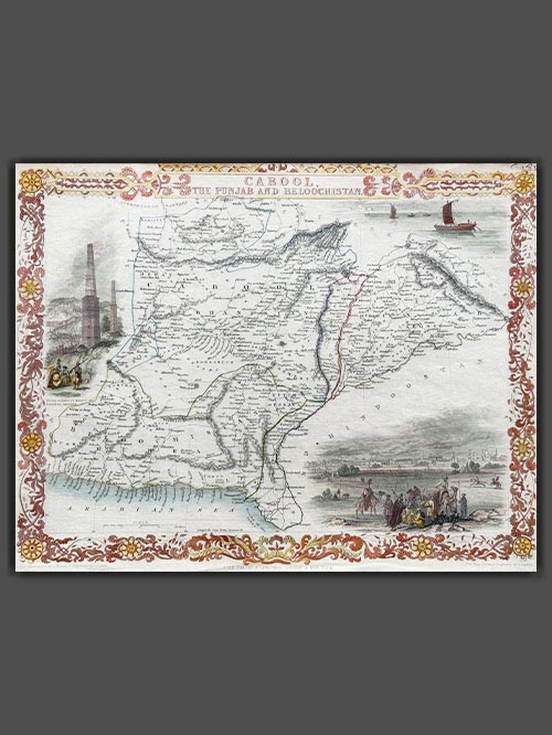

Pub. London
Original engraved map by J.Rapkin
This decorative engraved map by John Tallis, drawn by John Rapkin and published in 1851 for Tallis’s Illustrated Atlas and Modern History of the World, depicts present-day Afghanistan and Pakistan. Renowned for its artistic details, the map features decorative vignettes of regional landmarks, including boats on the Indus River, the city of Lahore, and the fortress and minarets of Ghazni, showcasing the cultural and architectural heritage of the region. Created during the era of the First Anglo-Afghan War (1839–1842) and the “Great Game” rivalry between Britain and Russia, this map highlights the geopolitical significance of the region.
Tallis and Company were map publishers based in London. They traded under various names including L.Tallis, John Tallis and John Tallis & Co.between 1838 and 1850. In 1851 their maps were published by the ‘London Printing and Publishing Co’., in both London and New York. Although he only issued one World Atlas, John Tallis, the founder of the firm, is among the best known of all map makers. The maps with small vignettes issued between 1850 and 1851 to commemorate the Great Exhibition in London are considered the last great series of decorative maps. They combine fine cartographical detail within an attractive border. Around the map there are several small but decorative vignettes depicting particular views, buildings, local inhabitants or the flora and fauna of that region.
Size (cms): 26.5(H) x 35(W)
Size (inches): 10.5(H) x 14(W)
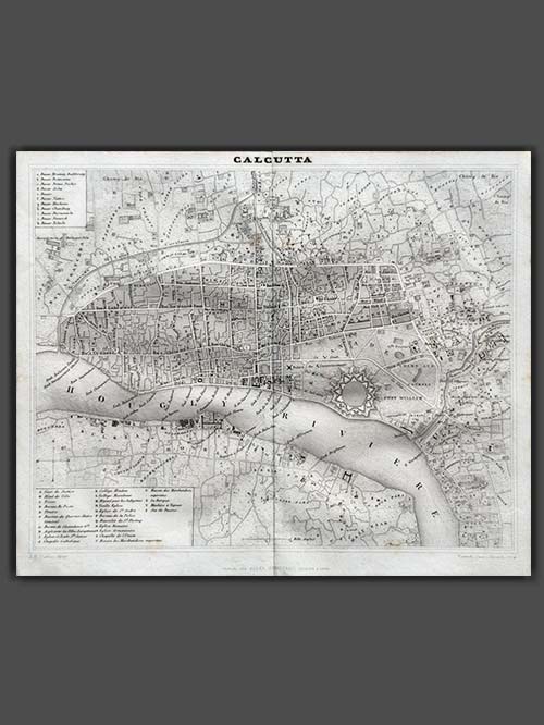

Original engraved map by Jules Renouard
Finely engraved Map of Calcutta by Jules Renouard, published in Paris circa 1839, showcasing a detailed city plan with Fort William on the Hooghly River and its surrounding areas. The map includes two inset keys identifying prominent historical buildings.
Jules Renouard (1798–1854) was a prominent French book dealer, editor, publisher, and bibliographer. Born in Paris to revolutionary and book dealer Antoine-Augustin Renouard, he studied at the Lycée Louis-le-Grand before briefly pursuing banking in London. In 1826, he inherited his father’s book business and became a key figure in the trade. Renouard co-founded the Cercle de la Librairie (Book Dealers’ Association) in 1847.
Image Size (cms): 22.5(H) x 26.5(W)
Image Size (inches): 9(H) x 10.5(W)
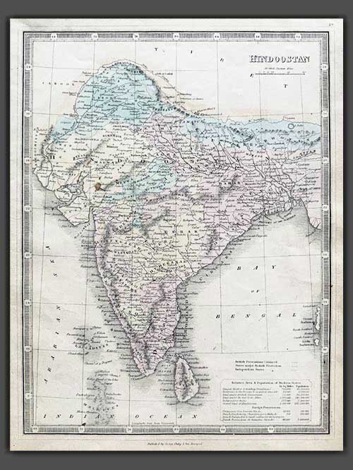

Original engraved map by George Philip & Son
Detailed map of India with two inset cartouches of area and population of the British states and the foreign possessions namely the Portuguese, Dutch, French and Danish. It was published by George Philip & Son in Liverpool circa 1858.
George Philip (1800–1882) was a Scottish map publisher and cartographer who founded his own firm in Liverpool in 1834 after apprenticing with a printer and bookseller. Initially focusing on educational materials, he collaborated with noted cartographers like John Bartholomew Sr. and August Petermann. In 1848, he brought his son, George Philip Jr. (1823–1902), into the business, renaming it George Philip & Son Ltd. Under George Jr., the company became a major publishing house and later established the London Geographical Institute, embracing modern printing techniques to produce high-quality, affordable maps on a large scale.
Image Size (cms): 32(H) x 24.5(W)
Image Size (inches): 12.5(H) x 9.5(W)
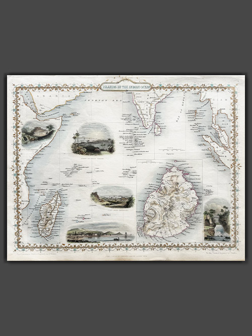

Pub. London
Original engraved map by J.Rapkin
This striking map of the Islands in the Indian Ocean, created by John Tallis, drawn by John Rapkin, and published in 1851 for Tallis’s Illustrated Atlas and Modern History of the World, offers a detailed depiction of the region. It showcases the Seycelles, the Maldives, Bourbon, and Mauritius, with an inset detailing the Island of Mauritius. The map features decorative vignettes including of Point De Gall, Ceylon, and Port Louis in Mauritius, capturing the essence of these exotic locations.
Tallis and Company were map publishers based in London. They traded under various names including L.Tallis, John Tallis and John Tallis & Co.between 1838 and 1850. In 1851 their maps were published by the ‘London Printing and Publishing Co’., in both London and New York. Although he only issued one World Atlas, John Tallis, the founder of the firm, is among the best known of all map makers. The maps with small vignettes issued between 1850 and 1851 to commemorate the Great Exhibition in London are considered the last great series of decorative maps. They combine fine cartographical detail within an attractive border. Around the map there are several small but decorative vignettes depicting particular views, buildings, local inhabitants or the flora and fauna of that region.
Size (cms): 27.5(H) x 36(W)
Size (inches): 11(H) x 14(W)
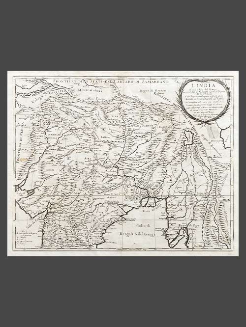

Pub. Rome by Giacomo Giovanni Rossi
Original engraved map
This is a fine representation of the Cantelli-Rossi map showcasing Northern India, Pakistan, Afghanistan, and Tibet. The map’s title includes a dedication to Jean-Baptiste Tavernier. It covers the northern frontier, reaching up to Cabul, Samarkand, Nupal, Boutan, and Lassa. Notably, the sources of the Indus and Ganges Rivers are accurately depicted on the map.
Cantelli (1643-1695), a geographer and cartographer from Montorsello near Vignola, began his journey in Bologna, where he pursued humanistic studies. In 1669, he became the secretary to Marquis Obizzo da Ferrara before traveling to Venice and eventually Paris. There, he established connections with prominent French geographers of the time, including Du Val, Nicola Sanson, and Michel Antoine Baudrand. Cantelli collaborated with the renowned De Rossi cartographic workshop, which published most of his maps. With a growing reputation as a skilled cartographer, Cantelli caught the attention of Pope Innocent XI and the Duke of Modena and Reggio Francesco II d’Este, both of whom sought him as their official cartographer. He chose to work for Francesco II and was appointed court geographer in November 1685. Over the following years, he produced numerous maps of European countries and territories. The majority of his maps were featured in the well-known Mercurio Geografico atlas, published in Rome by the De Rossi family.
Size (cms): 44(H) x 55(W)
Size (inches): 17.5(H) x 21.5(W)
Mounted Size (cms): 64(H) x 75(W)
Mounted Size (inches): 25(H) x 29.5(W)
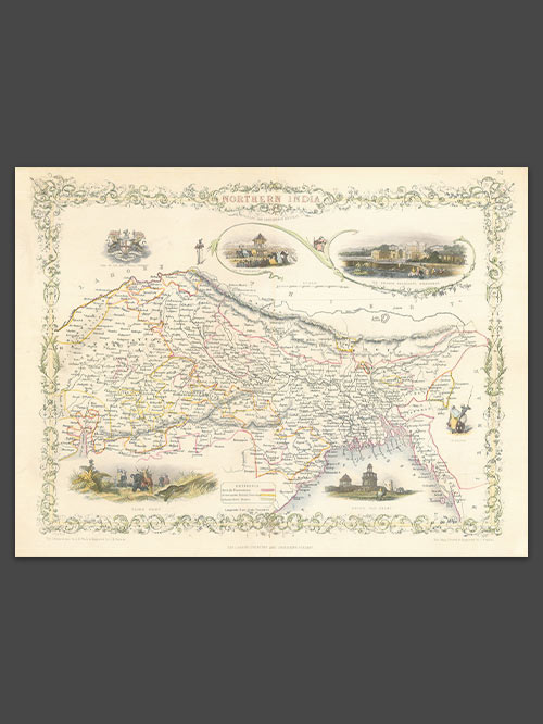

Pub. London
Original engraved map by J.Rapkin
An appealing map of Northern India covering the region from Surat on the west coast to Puri on the east coast, extending to the borders of Tibet, Burma, and Pakistan (Lahore). It features several vignettes, including a Tiger Hunt, Ruins of Old Delhi, the Car of Juggernaut (Jagannatha), the British Residency at Hyderabad, and a seal of the East India Company. The map is bordered by a decorative floral design.
Size (cms): 26(H) x 34(W)
Size (inches): 10(H) x 13.5(W)
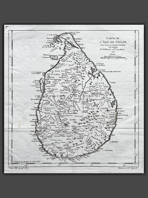

Original engraved plan by Jacques-Nicolas Bellin (1703–1772)
This finely engraved map, titled “Carte de L’Isle de Ceylon,” showcases Sri Lanka and originates from Jacques-Nicolas Bellin’s renowned Le Petit Atlas Maritime, first published in Paris in 1764.
Jacques-Nicolas Bellin was a pivotal figure in 18th-century cartography, serving as Hydrographer to the French Navy and the first Ingénieur Hydrographe at the French Dépôt des cartes et plans de la Marine. Over a 50-year career, Bellin produced hundreds of maps and charts celebrated for their accuracy and functionality, setting a high standard in European cartography. His works included major sea atlases such as Neptune François (1753), Hydrographie Française (1756), and the comprehensive Petit Atlas Maritime (1764), featuring 580–581 finely detailed charts. Bellin also contributed extensively to Diderot’s Encyclopédie and Abbé Prévost’s Histoire Générale des Voyages. A child of the Enlightenment, Bellin prioritized scholarly precision and cited his sources diligently, distinguishing his work from the more decorative styles of earlier mapmakers. His contributions cemented France’s dominance in cartography and influenced his student, Rigobert Bonne, who succeeded him at the Dépôt.
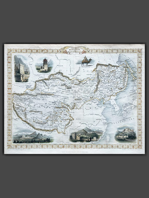

Pub. London
Original engraved map by J.Rapkin
This decorative map of Tibet, Mongolia and Manchuria was published in 1851 by John Tallis and Company and is a stunning example of 19th-century cartography. Engraved by John Rapkin, with vignettes depicting Leh in Ladakh, a stretch of the Great Wall of China and Llhasa all framed by an ornate geometric border.
Tallis and Company were map publishers based in London. They traded under various names including L.Tallis, John Tallis and John Tallis & Co.between 1838 and 1850. In 1851 their maps were published by the ‘London Printing and Publishing Co’., in both London and New York. Although he only issued one World Atlas, John Tallis, the founder of the firm, is among the best known of all map makers. The maps with small vignettes issued between 1850 and 1851 to commemorate the Great Exhibition in London are considered the last great series of decorative maps. They combine fine cartographical detail within an attractive border. Around the map there are several small but decorative vignettes depicting particular views, buildings, local inhabitants or the flora and fauna of that region.
Size (cms): 26.5(H) x 34(W)
Size (inches): 10.5(H) x 13.5(W)
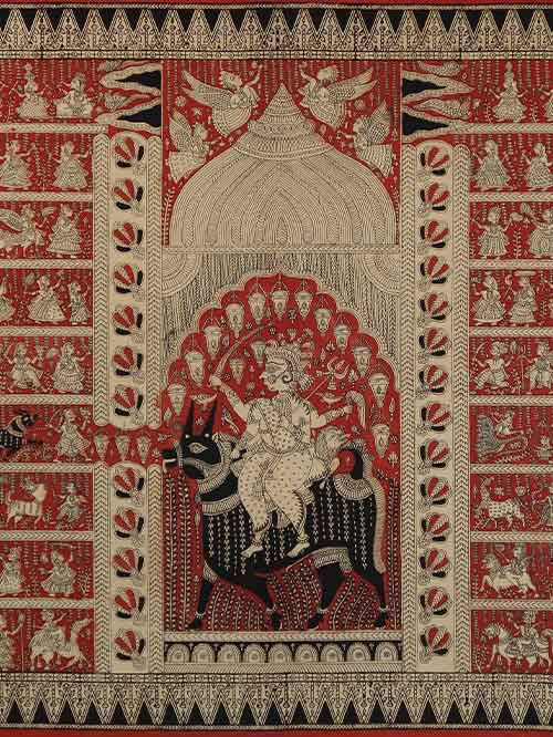

Gujarat
Mordants, painted and printed, and dyes on cotton cloth
The cloth features a prominent, centrally placed iconic image of Meladi Mata enshrined within a pavilion. A folk goddess worshiped by the Vaghri community of Gujarat, Meladi Mata is identified by her mount, the black goat. The four armed Goddess is sitting astride a goat carrying various weapons and implements. Around the central form on either side, are horizontal registers demarcated with lines. These registers are filled with rows of small hand-printed figures; some, portraying devotees, while others are singular images representing mythological characters or deities. On the left side in the middle register, a priest is depicted leading a buffalo to the central pavilion. On the right side, one row depicts various manifestations of the mother-goddess such as Ambika on a Tiger and Khodiar on a crocodile. Above them are depictions from the Hindu Epics, Mahabharata and Ramayana including Rama and Lakshman hunting the two-headed deer Maricha. The overall composition with its rows of devotees replicates the grand religious ceremony that would take place. The pictorial area of the composition is framed by geometric and floral bands.
In many regions of India, various types of imaged temple cloths, executed with different materials and techniques, have originated to serve narrative, iconic, or ritual ends for diverse groups of believers. One such tradition is found in Gujarat, where temple cloths painted and printed with mordants that combine with dyes to fix their colors are a component in goddess worship. The cloths, which were formerly made in villages in the areas surrounding Ahmedabad but now probably are produced only in the city proper, honour the Great Goddess under the aspect of Mother Goddess (Mata) one or more of several manifestations peculiar to Gujarat, such as Ambika on tiger, Bahuchara on a cock, Meladi on a billy goat, Khodiar on a crocodile, and Vihat on a water buffalo.
Size (cms): 99(H) x 159(W)
Size (inches): 39(H) x 62.5(W)
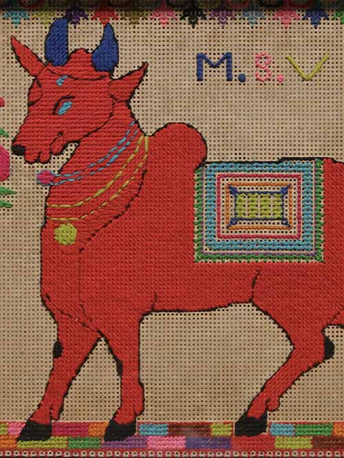

Chettinad (Tamil Nadu)
cross stitch embroidery
This whimsical cross stitch embroidery artwork depicts a bright orange caparisoned Nandi with blue horns stands facing left between two trees.
Framed Size (cms): 32(H) x 49(W)
Framed Size (inches): 12.5(H) x 19.5(W)
