“Tiger Vahana” has been added to your cart.
View cart
-


Orissa
Brass alloy
A beautiful patinated tantric ritual vessel with a stupa shaped lid. Symbols related to water and fertility and depicted including rows of grains, two step wells in cruciform shape, sun and moon symbols and five water Goddesses.
The Sätiasarā are non-Brahminic river deities or water nymphs worshiped primarily in rural Maharashtra. They have no distinctive mythology, and their cult lacks temples and priests, festivals and places of pilgrimage. They are considered sisters, depicted up to seven in number and are sometimes accompanied by Mhaskoba, their brother. Little is known about their mythology and they are associated with fertility. If angered, they are considered to harm women, mostly related to maternity, and are responsible for infertility, miscarriage or death of infants. To appease them, up to thirty-four different items such as fruits, flowers, small trinkets, and cosmetics, seven at a time, must be placed in seven new baskets and deposited in a waterhole by the river. This vessel was probably used as part of the puja (prayer) ritual to appease the Goddesses.
Size (cms): 14.5(H) x 11(W) x 11(D)
Size (inches): 5.5(H) x 4.5(W) x 4.5(D)
-
")
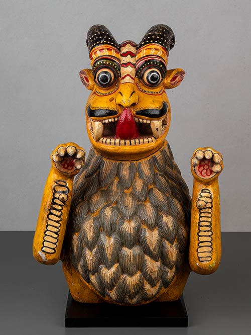
Karnataka
Wood, extensively polychromed
This striking large Tiger Vahana with an unusual, prominent flowing mane. The tiger has wide bulging eyes and an open mouth with large exposed teeth and a long protruding tongue. His fore legs are raised, as if to pounce.
The tiger is the vehicle of, and sacred to, the Hindu goddess, Durga. From a certain perspective she is India’s Mother Nature, for she is the deification of Energy. Her consort, Shiva, sometimes evoked as Shambo, wears a tiger skin to indicate that he is beyond the bounds of the natural world.
Size (cms): 61(H) x 38(W) x 27(D)
Size (inches): 24(H) x 15(W) x 10.5(D)
-
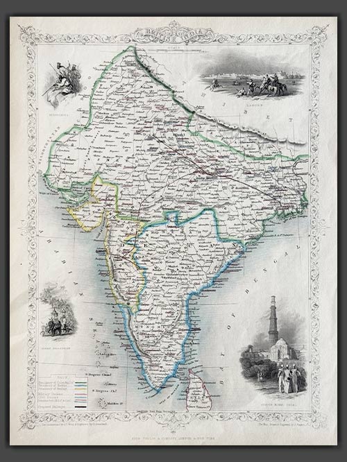

Pub. London
Original engraved map by J.Rapkin
This decorative map of British India, published in 1851 by John Tallis and Company, is a stunning example of 19th-century cartography. Engraved by John Rapkin, with vignettes by A.H. Wray and G. Greenbach, the map highlights the Madras, Calcutta, and Bombay Presidencies, as well as planned railway lines throughout the region. The decorative vignettes depict iconic landmarks such as Lahore, the Qutub Minar in Delhi, an Indian procession, and the Beloochees, all framed by an ornate flowered border.
Tallis and Company were map publishers based in London. They traded under various names including L.Tallis, John Tallis and John Tallis & Co.between 1838 and 1850. In 1851 their maps were published by the ‘London Printing and Publishing Co’., in both London and New York. Although he only issued one World Atlas, John Tallis, the founder of the firm, is among the best known of all map makers. The maps with small vignettes issued between 1850 and 1851 to commemorate the Great Exhibition in London are considered the last great series of decorative maps. They combine fine cartographical detail within an attractive border. Around the map there are several small but decorative vignettes depicting particular views, buildings, local inhabitants or the flora and fauna of that region.
Size (cms): 36(H) x 26(W)
Size (inches): 14(H) x 10(W)
-
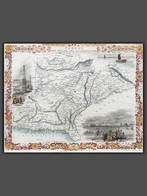

Pub. London
Original engraved map by J.Rapkin
This decorative engraved map by John Tallis, drawn by John Rapkin and published in 1851 for Tallis’s Illustrated Atlas and Modern History of the World, depicts present-day Afghanistan and Pakistan. Renowned for its artistic details, the map features decorative vignettes of regional landmarks, including boats on the Indus River, the city of Lahore, and the fortress and minarets of Ghazni, showcasing the cultural and architectural heritage of the region. Created during the era of the First Anglo-Afghan War (1839–1842) and the “Great Game” rivalry between Britain and Russia, this map highlights the geopolitical significance of the region.
Tallis and Company were map publishers based in London. They traded under various names including L.Tallis, John Tallis and John Tallis & Co.between 1838 and 1850. In 1851 their maps were published by the ‘London Printing and Publishing Co’., in both London and New York. Although he only issued one World Atlas, John Tallis, the founder of the firm, is among the best known of all map makers. The maps with small vignettes issued between 1850 and 1851 to commemorate the Great Exhibition in London are considered the last great series of decorative maps. They combine fine cartographical detail within an attractive border. Around the map there are several small but decorative vignettes depicting particular views, buildings, local inhabitants or the flora and fauna of that region.
Size (cms): 26.5(H) x 35(W)
Size (inches): 10.5(H) x 14(W)
-
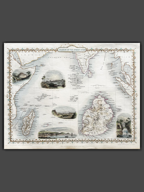

Pub. London
Original engraved map by J.Rapkin
This striking map of the Islands in the Indian Ocean, created by John Tallis, drawn by John Rapkin, and published in 1851 for Tallis’s Illustrated Atlas and Modern History of the World, offers a detailed depiction of the region. It showcases the Seycelles, the Maldives, Bourbon, and Mauritius, with an inset detailing the Island of Mauritius. The map features decorative vignettes including of Point De Gall, Ceylon, and Port Louis in Mauritius, capturing the essence of these exotic locations.
Tallis and Company were map publishers based in London. They traded under various names including L.Tallis, John Tallis and John Tallis & Co.between 1838 and 1850. In 1851 their maps were published by the ‘London Printing and Publishing Co’., in both London and New York. Although he only issued one World Atlas, John Tallis, the founder of the firm, is among the best known of all map makers. The maps with small vignettes issued between 1850 and 1851 to commemorate the Great Exhibition in London are considered the last great series of decorative maps. They combine fine cartographical detail within an attractive border. Around the map there are several small but decorative vignettes depicting particular views, buildings, local inhabitants or the flora and fauna of that region.
Size (cms): 27.5(H) x 36(W)
Size (inches): 11(H) x 14(W)
-

Pub. London
Original engraved map by J.Rapkin
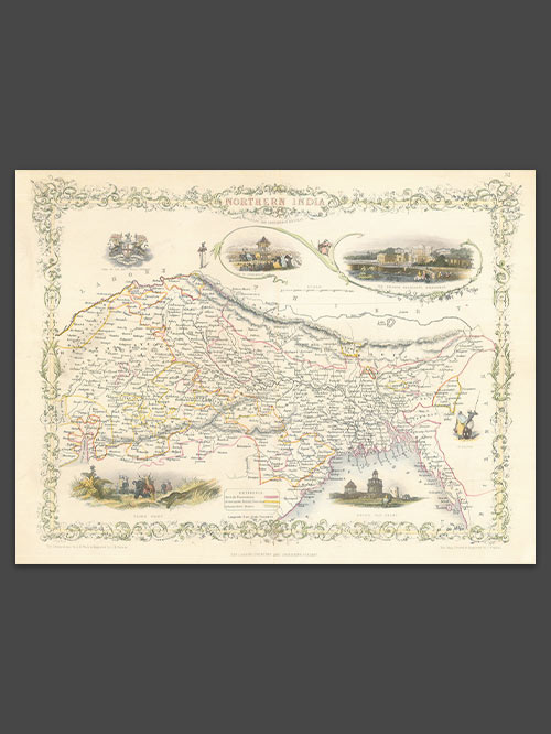
An appealing map of Northern India covering the region from Surat on the west coast to Puri on the east coast, extending to the borders of Tibet, Burma, and Pakistan (Lahore). It features several vignettes, including a Tiger Hunt, Ruins of Old Delhi, the Car of Juggernaut (Jagannatha), the British Residency at Hyderabad, and a seal of the East India Company. The map is bordered by a decorative floral design.
Tallis and Company were map publishers based in London. They traded under various names including L.Tallis, John Tallis and John Tallis & Co.between 1838 and 1850. In 1851 their maps were published by the ‘London Printing and Publishing Co’., in both London and New York. Although he only issued one World Atlas, John Tallis, the founder of the firm, is among the best known of all map makers. The maps with small vignettes issued between 1850 and 1851 to commemorate the Great Exhibition in London are considered the last great series of decorative maps. They combine fine cartographical detail within an attractive border. Around the map there are several small but decorative vignettes depicting particular views, buildings, local inhabitants or the flora and fauna of that region.
Size (cms): 26(H) x 34(W)
Size (inches): 10(H) x 13.5(W)
-

Pub. London
Original engraved map by J.Rapkin
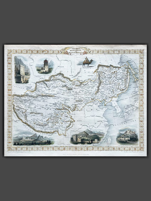
This decorative map of Tibet, Mongolia and Manchuria was published in 1851 by John Tallis and Company and is a stunning example of 19th-century cartography. Engraved by John Rapkin, with vignettes depicting Leh in Ladakh, a stretch of the Great Wall of China and Llhasa all framed by an ornate geometric border.
Tallis and Company were map publishers based in London. They traded under various names including L.Tallis, John Tallis and John Tallis & Co.between 1838 and 1850. In 1851 their maps were published by the ‘London Printing and Publishing Co’., in both London and New York. Although he only issued one World Atlas, John Tallis, the founder of the firm, is among the best known of all map makers. The maps with small vignettes issued between 1850 and 1851 to commemorate the Great Exhibition in London are considered the last great series of decorative maps. They combine fine cartographical detail within an attractive border. Around the map there are several small but decorative vignettes depicting particular views, buildings, local inhabitants or the flora and fauna of that region.
Size (cms): 26.5(H) x 34(W)
Size (inches): 10.5(H) x 13.5(W)
-
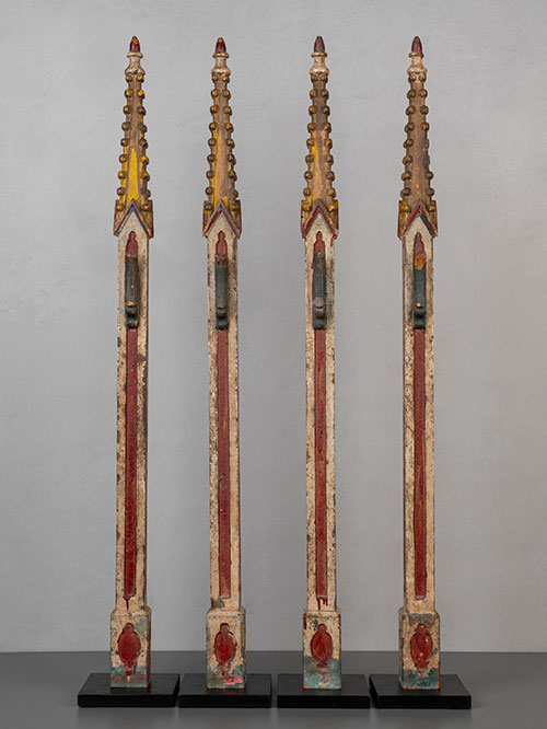

Goa
Wood with original polychroming
A sculptural set of four slim and elegant polychromed gothic style altar spires.
The Christians of Southern India have a long history and are one of the oldest Christian communities. They trace their origins to St. Thomas, an apostle of Jesus, who arrived in AD 52 and spread the new religion to other parts of the region. Despite the emergence of Roman Catholicism during Portuguese rule, Christianity remains strong in southern India with active churches and significant attendance on Sundays and feast days.
Magnificently adorned with churches and convents, Goa is often considered the Rome of the Orient, with its churches imitating grand European cathedrals featuring lofty halls, intricate wooden altars, and impressive masonry facades in the European baroque or neo-classical style. Hired by the bishops and priests, Indian woodworkers skilfully crafted altar carvings, images, and altarpieces that became the ritual and visual focal points within the interiors of churches. While these pieces were originally copied from and inspired by models imported from Portugal, the woodworkers began to showcase their creativity by blending European and Indian imagery and design conventions. The resulting art, known as Indo-Portuguese, represents a subtle fusion of elements brought from Europe with a rich local tradition. In its early stages, pieces were primarily crafted for both ecclesiastical and secular purposes. Altars, candlesticks, lecterns, and other objects carved with Christian symbolism conveyed the superiority of the new religion on Indian soil in imposing physical terms. These objects also showcased artistic prowess, often adorned with vibrant colours using hard wax and highlighted with gold.
Individual Sizes (cms): 113(H) x 16(W) x 16(D) each
Individual Size (inches): 44.5(H) x 6.5(W) x 6.5(D) each

