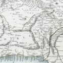
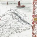
Map of Cabool, Punjab and Beloochistan
Pub. London
Original engraved map by J.Rapkin
Size (cms): 26.5(H) x 35(W)
Size (inches): 10.5(H) x 14(W)

Pub. London
Original engraved map by J.Rapkin
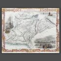
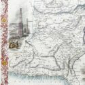
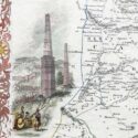
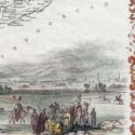
This decorative engraved map by John Tallis, drawn by John Rapkin and published in 1851 for Tallis’s Illustrated Atlas and Modern History of the World, depicts present-day Afghanistan and Pakistan. Renowned for its artistic details, the map features decorative vignettes of regional landmarks, including boats on the Indus River, the city of Lahore, and the fortress and minarets of Ghazni, showcasing the cultural and architectural heritage of the region. Created during the era of the First Anglo-Afghan War (1839–1842) and the “Great Game” rivalry between Britain and Russia, this map highlights the geopolitical significance of the region.
Tallis and Company were map publishers based in London. They traded under various names including L.Tallis, John Tallis and John Tallis & Co.between 1838 and 1850. In 1851 their maps were published by the ‘London Printing and Publishing Co’., in both London and New York. Although he only issued one World Atlas, John Tallis, the founder of the firm, is among the best known of all map makers. The maps with small vignettes issued between 1850 and 1851 to commemorate the Great Exhibition in London are considered the last great series of decorative maps. They combine fine cartographical detail within an attractive border. Around the map there are several small but decorative vignettes depicting particular views, buildings, local inhabitants or the flora and fauna of that region.
Size (cms): 26.5(H) x 35(W)
Size (inches): 10.5(H) x 14(W)